Projects from the Geothermal Hackathon 2021

geothermal_skull_thumb.png

The second Geothermal Hackathon happened last week. Timed to coincide with the Geosciences virtual event of the World Geothermal Congress, our 2-day event brought about 24 people together in the famous Software Underground Chateau (I’m sorry if I missed anyone!). For comparison, last year we were 13 people, so we’re going in the right direction! Next time I hope we’re as big as one of our ‘real world’ events — maybe we’ll even be able to meet up in local clusters.

Here’s a rundown of the projects at this year’s event:

Induced seismicity at Espoo, Finland

Alex Hobé, Mohsen Bazagan and Matteo Niccoli

Alex’s original workflow for creating dynamic displays of microseismic events was to create thousands of static images then stack them into a movie, so the first goal was something more interactive. On Day 1 Alex built a Plotly widget with a time zoomer/slider in a Jupyter Notebook. On day 2 he and Matteo tried Panel for a dynamic 3D plot. Alex then moved the data into LLNL Visit for fully interactive 3D plots. The team continues to hack on the idea.

geothermal_hack_2021_seismic.png

Fluid inclusions at Coso, USA

Diana Acero-Allard, Jeremy Zhao, Samuel Price, Lawrence Kwan, Jacqueline Floyd, Brendan, Gavin, Rob Leckenby and Martin Bentley

Diana had the idea of a gas analysis case study for Coso Field, USA. The team’s specific goal was to develop visualization tools for interetpaton of fluid inclusion gas data to identify fluid types, regions of permeability, and geothermal processes. They had access to analyses from 29 wells, requiring the usual data science workflow: find and load the data, clean the data, make some visualizations and maps, and finally analyse the permeability. GitHub repo here.

geothermal_hack_2021_fluid-incl.png

Utah Forge data pipeline

Andrea Balza, Evan Bianco, and Diego Castañeda

Andrea was driven to dive into the Utah FORGE project. Navigating the OpenEI data portal was a bit hit-and-miss, having to download files to get into ZIP files and so on (this is a common issue with open data repositories). The team eventually figured out how to programmatically access the files to explore things more easily — right from a Jupyter Notebook. Their code for any data on the OpenEI site, not just Utah FORGE, so it’s potentially a great research tool. GitHub repo here.

geothermal_hack_2021_forge.png

Pythonizing a power density estimation tool

Irene Wallis, Jan Niederau, Hannah Wood, Will Middlebrook, Jeff Jex, and Bill Cummings

Like a lot of cool hackathon projects, this one started with spreadsheet that Bill created to simplify the process of making power density estimates for geothermal fields under some statistical assumptions. Such a clear goal always helps focus the mind and the team put together some Python notebooks and then a Streamlit app — which you can test-drive here! From this solid foundation, the team has plenty of plans for new directions to take the tool. GitHub repo here.

geothermal_hack_2021_streamlit2.png
geothermal_hack_2021_streamlit1.png

Computing boiling point for depth

Thorsten Hörbrand, Irene Wallis, Jan Niederau and Matt Hall

Irene identified the need for a Python tool to generate boiling-point-for-depth curves, accommodating various water salinities and chemistries. As she showed during her recent TRANSFORM tutorial (which you must watch!), so-called BPD curves are an important part of geothermal well engineering. The team produced some scripts to compute various scenarios, based on corrections in the IAPWS standards and using the PHREEQC aqueous geochemistry modeling software. GitHub repo here.

geothermal_hack_2021_bpd-curves.png

A big Thank You to all of the hackers that came along to this virtual event. Not quite the same as a meatspace hackathon, admittedly, but Gather.town + Slack was definitely an improvement over Zoom + Slack. At least we have an environment in which people can arrive and immediately get a sense of what is happening in the event. When you realize that people at the tables are actually sitting in Canada, the US, the UK, Switzerland, South Africa, and Auckland — it’s clear that this could become an important new way to collaborate across large distances.

geothermal_hack_2021_chateau.png

Do check out all these awesome and open-source projects — and check out the #geothermal channel in the Software Underground to keep up with what happens next. We’ll be back in the future — perhaps the near future! — with more hackathons and more geothermal technology. Hopefully we’ll see you there! 🌋

The hot rock hack is back

shirt_skull.png

Last year we ran the first ever Geothermal Hackathon. As with all things, we started small, but energetic: fourteen of us worked on six projects. Topics ranged from project management to geological mapping to natural language processing. It was a fun two days not thinking about coronavirus.

This year we’ll be meeting up on Thursday 13 and Friday 14 May, starting right after the Geoscience Virtual Event of the World Geothermal Congress. Everyone is invited — geoscientists, engineers, data nerds, programmers. No experience of geothermal is necessary, just creativity and curiosity.

Projects are already being discussed on the Software Underground; here are some of the ideas:

  • Data-munging project for Utah Forge, especially well 58-32.

  • Update the Awesome list Thomas Martin started last year.

  • Implementing classic, or newly published, equations and algorthims from the literature.

I expect the preceeding WGC event will spark some last-minute projects too. But for the time being, you’re welcome to add or vote on ideas on the event page. What tools or visualizations would you find useful?


Build some digital geo skills

📣 If you’re looking to build up your coding skills before the hackathon — or for a research project or an idea at work — join us for a Python class. We teach the fundamentals of Python, NumPy and matplotlib using geological and geophysical examples and geo-familiar datasets. There are two classes coming up in May (Digital Geology) and June (Digital Geophysics).

The hot rock hack happened

shirt_skull.png

I was excited about the World Geothermal Congress this year. (You remember conferences — big, expensive, tiring lecture-marathons that scientists used to go to. But sometimes they were fun.)

Until this year, the WGC has only happened every 5 years and we missed the last one because it was in Australia… and the 2023 edition (it’s moving to a 3-year cycle) will be in China. So this year’s event, just a stone’s throw away in Iceland, was hotly anticipated.

And it still is, because now it will be next May. And we’ll be doing a hackathon there! You should come, get it in your calendar: 27 and 28 May 2021.

Meanwhile, this year… we moved our planned hackathon online. For the record, here’s what happened at the first Geothermal Hackathon.

Logistics: Timezones are tricky

There’s no doubt, the biggest challenge was the rotation of the earth (though admittedly it has other benefits). I believe the safest way to communicate times to a global audience is UTC, so I’ll stick to that here. It’s not ideal for anyone (except Iceland, appropriately enough in this case) but it reduces errors. We started at 0600 UTC and went until about 2100 UTC each day; about 15 hours of fun. I did check in briefly at 0000 UTC on each morning (my evening), in case anyone from New Zealand showed up, but no-one did.

Rob Leckenby and Martin Bentley, both in the UTC+2 zone, handled the early morning hosting, with me, Evan and Diego showing up a few hours later (we’re all in Canada, UTC–a few). This worked pretty well even though, as usual, the hackers were all perfectly happy and mostly self-sufficient whether we were there or not.

Technology-wise, we met up on Zoom, which was good for the start and the end of the day, and also for getting the attention of others in between (many people left the audio open, one ear to the door, so to speak.) Alongside Zoom we used the Software Underground’s Slack. As well as the #geothermal channel, each project had a channel — listed below — which meant that each project could have a separate video meetup at any time, as well as text-based chat and code-sharing. It was a good combination.

Let’s have a look at the hacks.


Six projects

An awesome list for geothermal — #geothermal-awesomeThomas Martin (Colorado School of Mines), with some input from me and others, made a great start on an ‘awesome list’ document for geothermal, with a machine learning amphasis. He lists papers, tools, and open data. You can read (or contribute to!) the document here.

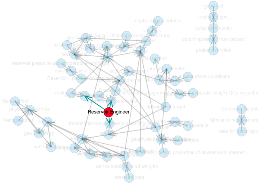
Collaboration tools for geothermal teams — #geothermal-collaboration-tools — Alex Hobé (Uppsala) and Valentin Métraux (GEO2X), with input from Martin Bentley and others, had a clear vision for the event: he wanted to map out the flow of data and interpretations between professionals in a geothermal project. I’ve seen similar projects get nowhere near as far in 2 months as Alex got in 2 days. The team used Holoviews and NetworkX to make some nice graphics.

collaboration_map.png

GEOPHIRES web app — #geothermal-geophires — Marko Gauk (SeisWare) wanted to get into web apps at the event, and he succeeded! He built a web-based form for submitting jobs to a server running GEOPHIRES v2, a ‘full field’ geothermal project modeling tool. You can check out his app here.

Geothermal Natural Language Processing — #geothermal-nlp — Mohammad ‘Jabs’ Aljubran (Stanford), Friso (Denver), along with Rob and me, did some playing with the Stanford geothermal bibliographic database. Jabs and Friso got a nice paper recommendation engine working, while Rob and I managed to do automatic geolocation on the articles — and Jabs turned this into some great maps. Repo is here. Coming soon: a web app.

geothermal_map.png

Experiments with porepy — #geothermal-porepy — Luisa Zuluaga, Daniel Coronel, and Sam got together to see what they could do with porepy, a porous media simulation tool, especially aimed at modeling fractured and deformable rocks.

Radiothermic map of Nova Scotia — #geothermal-radiothermic — Evan Bianco downloaded some open data for Nova Scotia, Canada, to see if he could implement this workflow from Beamish and Busby. But the data turned out to be unscaled (among other things), and therefore probably impossible to use for quantitative purposes. At least he made progress on a nice map.

radiothermic_map_ns.png

All in all it was a fun couple of days. You can’t beat a hackathon for leaving behind emails and to-do lists for a day

The hacks are back

We ran the first geoscience hackathon over 7 years ago in Houston. Since then we’ve hosted another 26 subsurface hackathons — that’s 175 projects, and over 900 hackers. Last year, 10 of the 11 hackathons that Agile* facilitated were in-house.

This is exciting. It means that grass-roots, creative, high-speed collaboration and technology development is possible inside large corporations. But it came at the cost of reducing our public events… and we want to bring the hackathon experience to everyone!

So this year, as well as helping execute a dozen or so in-house hackathons, we’ll be running and supporting more public hackathons too. So if you’ve been waiting for a chance to learn to code or try a social coding event, or just hang out with a lot of nerdy geoscientists and engineers — here’s your chance!


May: Geothermal Hackathon

The first event of the year is a new one for us. We’ll be at the World Geothermal Congress in Reykjavik, Iceland, in the last week of April. The second weekend, 2 and 3 May, we’ll be running a hackathon on machine learning for geothermal subsurface applications. Iceland is only a short flight from the rest of Europe and many places in North America, so if you fancy something completely different, this is for you! Find out more and sign up.

[An earlier version of this post had the event on the previous weekend.]


June: Subsurface Hackathon (USA)

We’re back in Houston in June! The AAPG ACE is there — clashing with EAGE unfortunately — and we’ll be holding a (completely unrelated) hackathon on the weekend before: 5 to 7 June. Enthought is hosting the event in their beautiful new Houston digs, and Dell EMC is there too as a major sponsor. The theme is Tools… It’s going to be a big one! Find out more and sign up.

We are running two public Python classes before this event. Check them out.

houston-2020-sponsors.png
 

June: Amstel Hack (Europe)

The brilliant Filippo Broggini (ETHZ) is running a European hackathon again this year, again right before EAGE — and therefore the same weekend as the Houston event: 6 and 7 June. The event is being hosted at Shell’s Technology Centre in Amsterdam, and is guaranteed to be awesome. If you’re going to EAGE, it’s a no-brainer. Find out more and sign up.

We are also running a public Python class before this event. Check it out.

amstel-2020-sponsors.png
 

That’s it for now… I hope you can come to one of these events. If you’re just starting out on your technology journey, have no fear — these events are friendly and welcoming. If you can’t make any of them, don’t worry: there will be more in the autumn, so stay tuned. Or, if you want help making one happen at your company, get in touch.

GeoConvention highlights

We were in Calgary last week at the Canada GeoConvention 2017. The quality of the talks seemed more variable than usual but, as usual, there were some gems in there too. Here are our highlights from the technical talks...

Filling in gaps

Mauricio Sacchi (University of Alberta) outlined a new reconstruction method for vector field data. In other words, filling in gaps in multi-compononent seismic records. I've got a soft spot for Mauricio's relaxed speaking style and the simplicity with which he presents linear algebra, but there are two other reasons that make this talk worthy of a shout out:

  1. He didn't just show equations in his talk, he used pseudocode to show the algorithm.
  2. He linked to his lab's seismic processing toolkit, SeismicJulia, on GitHub.

I am sure he'd be the first to admit that it is early days for for this library and it is very much under construction. But what isn't? All the more reason to showcase it openly. We all need a lot more of that.

Update on 2017-06-7 13:45 by Evan Bianco: Mauricio, has posted the slides from his talk

Learning about errors

Anton Birukov (University of Calgary & graduate intern at Nexen) gave a great talk in the induced seismicity session. It was a lovely mashing-together of three of our favourite topics: seismology, machine-learning, and uncertainty. Anton is researching how to improve microseismic and earthquake event detection by framing it as a machine-learning classification problem. He's using Monte Carlo methods to compute myriad synthetic seismic events by making small velocity variations, and then using those synthetic events to teach a model how to be more accurate about locating earthquakes.

Figure 2 from Anton Biryukov's abstract. An illustration of the signal classification concept. The signals originating from the locations on the grid (a) are then transformed into a feature space and labeled by the class containing the event or…

Figure 2 from Anton Biryukov's abstract. An illustration of the signal classification concept. The signals originating from the locations on the grid (a) are then transformed into a feature space and labeled by the class containing the event origin. From Biryukov (2017). Event origin depth uncertainty - estimation and mitigation using waveform similarity. Canada GeoConvention, May 2017.

The bright lights of geothermal energy
Matt Hall

Two interesting sessions clashed on Wednesday afternoon. I started off in the Value of Geophysics panel discussion, but left after James Lamb's report from the mysterious Chief Geophysicists' Forum. I had long wondered what went on in that secretive organization; it turns out they mostly worry about how to make important people like your CEO think geophysics is awesome. But the large room was a little dark, and — in keeping with the conference in general — so was the mood.

Feeling a little down, I went along to the Diversification of the Energy Industry session instead. The contrast was abrupt and profound. The bright room was totally packed with a conspicuously young audience numbering well over 100. The mood was hopeful, exuberant even. People were laughing, but not wistfully or ironically. I think I saw a rainbow over the stage.

If you missed this uplifting session but are interested in contributing to Canada's geothermal energy scene, which will certainly need geoscientists and reservoir engineers if it's going to get anywhere, there are plenty of ways to find out more or get involved. Start at cangea.ca and follow your nose.

We'll be writing more about the geothermal scene — and some of the other themes in this post — so stay tuned. 


DID YOU KNOW?

You can get regular updates right to your email, just drop your address in the box:

The fine print: No spam, we promise! We never share email addresses with 3rd parties. Unsubscribe any time with the link in the emails. The service is provided by MailChimp in accordance with Canada's anti-spam regulations.

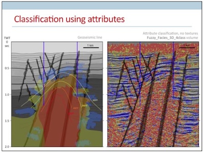
Geothermal facies from seismic

Here is a condensed video of the talk I gave at the SEG IQ Earth Forum in Colorado. Much like the tea-towel mock-ups I blogged about in July, this method illuminates physical features in seismic by exposing hidden signals and textures. 

This approach is useful for photographs of rocks and core, for satellite photography, or any geophysical data set, when there is more information to be had than rectangular and isolated arrangements of pixel values.

Click to download slides with notes!Interpretation has become an empty word in geoscience. Like so many other buzzwords, instead of being descriptive and specific jargon, it seems that everyone has their own definition or (mis)use of the word. If interpretation is the art and process of making mindful leaps between unknowns in data, I say, let's quantify to the best of our ability the data we have. Your interpretation should be iteratable, it should be systematic, and it should be cast as an algorithm. It should be verifiable, it should be reproducible. In a word, scientific.  

You can download a copy of the presentation with speaking notes, and access the clustering and texture codes on GitHub

The science of things we don't understand

I am at the EAGE Conference & Exhibition in Copenhagen. Yesterday I wrote up my highlights from Day 2. Today it's, yep, Day 3!

Amusingly, and depressingly, the highlight of the morning was the accidental five minute gap between talks in the land seismic acquisition session. Ralf Ferber and Felix Herrmann began spontaneously debating the sparsity of seismic data (Ferber doubting it, Herrmann convinced of it), and there was a palpable energy in the room. I know from experience that it is difficult to start conversations like this on purpose, but conferences need more of this.

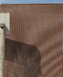
There was some good stuff in Ralf's two talks as well. I am getting out of my depth when it comes to non-uniform sampling (and the related concept of compressive sensing), but I am a closet signal analyst and I get a kick out of trying to follow along. The main idea is that you want to break aliasing, a type of coherent noise and a harmful artifact, arising from regular sampling (right). The way to break it is to introduce randomness and irregularity—essentially to deliberately introduce errors in the data. Ralf's paper suggested randomly reversing the polarity of receivers, but there are other ways. The trick is that we know what errors we introduced.

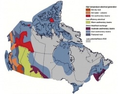
Geothermal in Canada. Image: GSC. As Evan mentioned recently, we've been doing a lot of interpretation on geothermal projects recently. And we both worked in the past on oil sands projects. Today I saw a new world of possiblity open up as Simon Weides of GFZ Potsdam gave his paper, Geothermal exploration of Paleozoic formations in central Alberta, Canada. He has assessed two areas: the Edmonton Peace River regions, but only described the former today. While not hot enough for electricity generation, the temperature in the Cambrian (81°–89°C) is suitable for so-called district heating projects, though it's so tight it would need fraccing. The Devonian is cooler, at 36°–59°C, but still potentially useful for greenhouses and domestic heat. The industrial applications in Alberta, where drilling is easy and inexpensive, are manifold.

I wandered in at the end of what seemed to be the most popular geophysics talk of the conferece: Guus Berkhout's Full wavefield migration — utilization of multiples in seismic migration. While I missed the talk, I was in time to catch a remark of his that resonated with me:

Perhaps we don't need the science of signals, but the science of noise. The science of noise is the science of things we don't understand, and that is the best kind of science. 

Yes! We, as scientists in the service of man, must get better at thinking about, worrying about, and talking about the things we don't understand. If I was feeling provocative, I might even say this: the things we understand are boring.

The brick image shows spatial aliasing resulting from poor sampling. Source: Wikipedian cburnett, under GFDL.

Thermogeophysics, whuh?

Earlier this month I spent an enlightening week in Colorado at a peer review meeting hosted by the US Department of Energy. Well-attended by about 300 people from organizations like Lawerence Livermore Labs, Berkeley, Stanford, Sandia National Labs, and *ahem* Agile, delegates heard about a wide range of cost-shared projects in the Geothermal Technologies Program. Approximately 170 projects were presented, representing a total US Department of Energy investment of $340 million.

I was at the meeting because we've been working on some geothermal projects in California's Imperial Valley since last October. It's fascinating, energizing work. Challenging too, as 3D seismic is not a routine technology for geothermal, but it is emerging. What is clear is that geothermal exploration requires a range of technologies and knowledge. It pulls from all of the tools you could dream up; active seismic, passive seismic, magnetotellurics, resistivity, LiDAR, hyperspectral imaging, not to mention the borehole and drilling technologies. The industry has an incredible learning curve ahead of them if Enhanced Geothermal Systems (EGS) are going to be viable and scalable.

The highlights of the event for me were not the talks that I saw, but the people I met during coffee breaks:

John McLennan & Joseph Moore at the the University of Utah have done some amazing laboratory experiments on large blocks of granite. They constructed a "proppant sandwich", pumped fluid through it, and applied polyaxial stress to study geochemical and stress effects on fracture development and permeability pathways. Hydrothermal fluids alter the proppant and gave rise to wormhole-like collapse structures, similar to those in the CHOPS process. They incorporated diagnostic imaging (CT-scans, acoustic emission tomography, x-rays), with sophisticated numerical simulations. A sign that geothermal practitioners are working to keep science up to date with engineering.

Stephen Richards bumped into me in the corridor after lunch after he overheard me talking about the geospatial work that I did with the Nova Scotia Petroleum database. It wasn't five minutes that passed before he rolled up his sleeves, took over my laptop, and was hacking away. He connected the WMS extension that he built as part of the State Geothermal Data to QGIS on my machine, and showed me some of the common file formats and data interchange content models for curating geothermal data on a continental scale. The hard part isn't nessecarily the implementation, the hard part is curating the data. And it was a thrill to see it thrown together, in minutes, on my machine. A sign that there is a huge amount of work to be done around opening data.

Dan Getman - Geospatial Section lead at NREL gave a live demo of the fresh prospector interface he built that is accesible through OpenEI. I mentioned OpenEI briefly in the poster presentation that I gave in Golden last year, and I can't believe how much it has improved since then. Dan once again confirmed this notion that the implementation wasn't rocket science, (surely any geophysicist could figure it out), and in doing so renewed my motivation for extending the local petroleum database in my backyard. A sign that geospatial methods are at the core of exploration and discovery.

There was an undercurrent of openness surrounding this event. By and large, the US DOE is paying for half of the research, so full disclosure is practically one of the terms of service. Not surprisingly, it feels more like science going on here, where innovation is being subsidized and intentionally accelerated because there is a demand. Makes me think that activity is a nessecary but not sufficient metric for innovation.