
News of the week
/Dips from pics
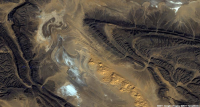 In collaboration with the Geological Survey of Canada, Pangaea Software have built a very nifty tool, Orion, for computing dip from satellite images and digital elevation models. With these two pieces of data, and some assumptions about scale, it's possible to deduce the dip of strata without getting your boots muddy. Matt heard all about this tool from the GSC collaborator, Paul Budkewitsch, at the 3P Arctic conference in Halifax last week; here's their abstract.
 Ocean bottom investment
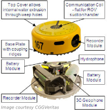
CGGVeritas has made a commitment to manufacture 800 new Trilobit four-component deepwater nodes for seismic acquisition, to add to its existing pool. The device has three oriented accelerometers plus a hydrophone in addition to an onboard battery and recording system. This all-in-one design can be deployed on the seabed by most ROVs, making it easy to place near platforms and other infrastructure that towed streamer and cable systems cannot access.
Arguably the industry leader in cableless systems is FairfieldNodal, who are already deploying more than a thousand nodes. It's great to see a big player like CGGVeritas coming to compete with this potentially transformative technology.
Update for Insight Earth
Colorado-based software company TerraSpark has just announced the release of Insight Earth 1.6, an integrated volume interpretation tool. Enhancements include a more interactive data import and export interface, improved velocity modeling, and upgrades to the automated fault extraction. In a January post, Evan highlighted an article by Stan Hammon of TerraSpark on the computational and psychological factors affecting intellegent design. It's inspired stuff.
Re-introducing SubSurfWiki
AgileWiki is now SubSurfWiki, at subsurfwiki.org. Please change your bookmarks! We felt that it was a little too Agile-centric and want to appear as open web-space for anything subsurface. We want it to grow, deepen and diversify, and above all be useful. So check it out and let us know if you have any feedback on utility, appearance and content.
More news... If you like this, check out previous news posts from Agile*
Orion is a trademark of Pangaea Software. Insight Earth is a trademark of TerraSpark. SubSurfWiki is a trademark of Agile Geoscience. The satellite image is copyright of Google. This regular news feature is for information only. We aren't connected with any of these organizations, and don't necessarily endorse their products or services.


 Except where noted, this content is licensed