Geophysical prospecting's roots

As a schoolboy, I used to frequent the second-hand bookshops of Reading, Cambridge, and all over the south east of England. Though not much of a collector, I was taken with the challenge once: Penguin's quarterly science magazine of the late 40s and early 50s: Science News. I completed the set only a few years ago. I'll be honest, while the articles were often very interesting, I was mainly interested in the beautiful cover design. Classic mid-20th Century Penguin.

Most of the articles are very dated of course, but I find them interesting to read nonetheless. Today, I thought I'd excerpt a 1948 article by one A Harford: Advances in geophysical prospecting. It's interesting because this post-war period was really the dawn of the golden age of the oil and gas industry. Naturally, this meant rapid advances in exploration geoscience, especially well logging, reflection seismology, and gravity-magnetics. No doubt wartime technology had its effects; certainly the development of seismic and signal processing technology was accelerated by the Great War and World War II. This article is mostly about magnetic surveys, but he touches on all of these technologies.

...geophysics hardly began until the 1920’s, since when it has expanded at a furious pace. Big business found that geophysics would detect new oil-fields with greater certainty than any other means and, as they found this new technique increased their profits, they lavished money upon it for many years. As more money was spent on better instruments and interpreters the successes increased until, in fifteen years, the gravity meter for instance reached ultimate sensitivity. Between them the physicists and geologists discovered numerous oilfields with relative ease and seemed to find the pace invigorating. Certainly the oil industry has created geophysics, which even now is little used outside problems connected with oil.
DOWNLOAD THE REST OF THE ARTICLE

The blustery language ('the oil industry created geophysics'!) and fearless modernism seems quaint now, but the rate of new oil and gas discoveries at the time was several times what it is today (see chart). I sometimes wonder if the thought of technology leading us has left us jaded; one often hears people react negatively to new tools or software: "We didn't need that in my day".

← Image from Wikipedia article on peak oil

To be sure, even as a committed technologist, I love the idea of spending more money on better interpreters! Like these gentlemen geophysicists, casually examining a seismic record at Lake Arthur, Louisiana, from Harford's article:

Part of me thinks the world has changed so much—hydrocarbons are much, much harder to find today—that this is all really just ancient history. But I also recognize that the tools we have are far more powerful, and our knowledge so much more profound: plate tectonics was still a hotly-debated concept in 1948, for example. So who really has the advantage?

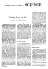
Disclaimer To the best of my knowledge, the original article first appeared in the October 1948 issue of Science News, published by Penguin Books of Harmondsworth, England. It is excerpted here, and made available for download, with their advice but not their explicit permission; Penguin is not involved in this website. To the best of my knowledge, the material is copyright free today; if you believe otherwise, get in touch.

What is unconventional?

Subsurface science in the oil industry has gradually shifted in emphasis over the last five, maybe ten, years. In 2000, much of the work being done in our field was focused on conventional oil and gas plays. Today, it seems like most of what we do has something to do with unconventional resources. And this is set to continue. According to the American Petroleum Institute, unconventional gas production accounts for almost 50% of today's US Lower 48 production total of about 65 billion cubic feet per day, and is expected to reach 64% by 2020. In Canada, where unconventional gas is also very important, unconventional oil is at least as significant to geoscientists, especially bitumen. According to the Alberta govermnent, production from the Athabasca oil sands in 2011 will be about 2 million barrels per day.

But what does 'unconventional' mean? The short answer is "not conventional", which is more helpful than it sounds, and the long answer is "it depends who you ask". This is because where you draw the line between conventional and unconventional depends on what you care most about. To illustrate the point, here are some points of view...

Read More

B is for bit depth

If you give two bits about quantitative seismic interpretation, amplitude maps, inversion, or AVO, then you need to know a bit about bits.

When seismic data is recorded, four bytes are used to store the amplitude values. A byte contains 8 bits, so four of them means 32 bits for every seismic sample, or a bit-depth of 32. As Evan explained recently, amplitude values themselves don’t mean much. But we want to use 32 bits because, at least at the field recording stage, when a day might cost hundreds of thousands of dollars, we want to capture every nuance of the seismic wavefield, including noise, multiples, reverberations, and hopefully even some signal. We have time during processing to sort it all out.

First, it’s important to understand that I am not talking about spatial or vertical resolution, what we might think of as detail. That’s a separate problem which we can understand by considering a pixelated image. It has poor resolution: it is spatially under-sampled. Here is the same image at two different resolutions. The one on the left is 300 × 240 pixels; on the right, 80 × 64 pixels (but reproduced at the same size as the other picture, so the pixels are larger). Click to read more...

Read More

Great geophysicists #2: Snellius

Willebrordus Snellius (1580–1626) was the Latin name that Dutchman Willebrord Snel van Royen, or plain Snell, used for all of his publications as a mathematician. He made great advances over his predessors by introducing trigonometric methods for measuring large distances across landcapes. He's regarded as the father of triangulation, which is widely applied in surveying, imaging, and event location. And he even tried to measure the radius of the earth.

His most famous contribution, Snell's law of refraction, has formed the basis of geometrical optics and is inherently ingrained in seismology. Snell's law is used to determine the direction of wave propagation through a refractive interface:  

How much waves bend depends on the ratio of velocities between the two media v2/ v1. You will notice that the right hand side of this equation is where Ibn Sahl left off.

Other mathematicians before him, Ibn Sahl for instance, were aware that light rays refracted when they entered media of different velocities, but Snellius was the first to describe this problem using trigonometry. He made his discovery in 1621, when he was 41 years old, but it was never published in his lifetime. René Descartes, the inventor of the cartesian coordinate and analytical geometry, published this law of refraction 16 years after Snell's death, as Descarte's law of refraction. But Snell was eventually widely attributed with the discovery in 1703 when Christiaan Huygens published Snell's results in his Dioptrica to explain, among other things why successive wavefronts travel in parallel.

Oleg Alexandrov via Wikipedia

In a classic analogy, a 'fast' region is the beach, a ' slow' region is the water, and the fastest way for a rescuer on the beach to get to a drowning person in the water is to run, then swim, along a path that follows Snell's law. The path a ray will take upon entering a media is the one that minimzes the travel time through that media (see Fermat's principle). Notice too that there are no arrows indicating the direction of ray propagation: whether the ray enters from above or below, the refraction behaviour is the same.

In seismology, Snell's law is used to describe how seismic waves bend and turn in accordance with contrasting velocities in the subsurface which is the foundation of surveying, image focusing, and event detection. It appears in ray-tracing, ray-parameterization, offset to angle estimations (used in AVO), anisotropy problems, velocity modeling, and traveltime tomography. Snellius, we salute you!

What is a darcy?

Permeability is the capacity of a porous material to transmit fluids. The SI unit of permeability is m2 (area) but the units adopted by the petroleum industry have been named after Henry Darcy, who derived Darcy's law. A darcy is a confusing jumble of units which combines a standardized set of laboratory experiments. By definition, a material of 1 darcy permits a flow of 1 cm3/s of a fluid with viscosity 1 cP (1 mPa.s) under a pressure gradient of 1 atm/cm across an area of 1 cm2.

Apart from having obscure units with an empirical origin, permeability can be an incredibly variable quantity. It can vary be as low as 10–9 D for tight gas reservoirs and shale, to 101 D for unconsolidated conventional reservoirs. Just as electrical resistivity, values are plotted on a logarithmic scale. Many factors such as rock type, pore size, shape and connectedness and can effect fluid transport over volume scales from millimetres to kilometres.

Okay then, with that said, what is the upscaled permeability of the cube of rock shown here? In other words, if you only had to find one number to describe the permeability of this sample, what would it be? I'll pause for a moment while you grab your calculator... Okay, got an answer? What is it?

Read More

Aerial geology

A few recent posts by others on aerial geology prompted me to gather them for future reference. Please add any I've missed to the comments!

Large collections

Both of these pages features lots of pictures from all over the United States, plus a few from other parts of the world. I was a bit surprised not to find collections of geological pictures taken from helicopters or hot air balloons. 

  •  John Louie's Aerial Geology with lots of images taken from commercial aircraft (like the one shown at right, of the Clayton Valley dunes in Nevada; from John's site).
  • Geology by Lightplane by flying geologist Louis Maher and photographer Charles Mansfield has dozens of pictures taken from a Cessna mostly during the late 1950's and early 1960's. Doc Searl's blog post (below) is about this wonderful collection.

Blog posts

Publications

Great geophysicists #1: Ibn Sahl

Abu Sa’d al-’Ala’ ibn Sahl was a mathematician in late 10th Century Persia, working for the hugely powerful Abbasid caliphate and probably based in Baghdad. He understood the mathematics of refraction, at least six hundred years before Dutchman Willebrord Snellius wrote it all down and eventually gave the sine law of refraction his name. Snellius’ ancestors in Europe, in Ibn Sahl’s time, were in the middle of the Dark Ages, waiting patiently for the Renaissance just three or four hundred years away. I'll tell more about Snellius in a future post.

Refraction—the bending of a wave's ray-path due to a change in velocity—had been studied by the Egyptian astronomer Ptolemy in the second century, but he was unable to figure out the mathematics fully. It’s not known whether Ibn Sahl knew of this work, but Ptolemy’s Optics was certainly translated into Arabic, so it seems likely that he did. There wasn’t, after all, that much to read in those days.

The key figure from his work On Burning Mirrors and Lenses is shown here. I have cropped out part of the figure; see the whole thing on Wikipedia. I redrew the diagram, and added some annotation to show how it relates to the usual formulation of Snell's Law. The ratio of the lengths of the hypotenuses AB to DB is equal to the reciprocal of the ratio of the refractive indices of the materials on either side of the vertical line. Phew!

Ibn Sahl’s work was brought much further along by one of his successors, Ibn Haitham, widely considered to be the founding father of optics. He was the first person to make a pinhole camera, and thereby prove that light travelled in straight lines.

In Our Time

When I lived in Calgary I walked 25 minutes to and from work every day. Melvyn Bragg's weekly BBC radio programme was always one of my favourite things to listen to on the way. Every show has the same format: an informal forty-minute discussion with three academics. But the quintessence of In Our Time is its diversity of topics: Avicenna to Yeats to the Aeneid to Zoroastrianism.

Over the years, Bragg and his guests have covered lots of geological subjects. The wonderful BBC keeps the archive completely open, so you can listen to any show any time. Here are the most geoscientiferous ones I can find in the archive:


Here are some others, less directly related to geoscience:


Tomorrow's programme is on random and pseudo-randomness. Can't wait!

Rock physics and steam

Over the last few weeks, I have been revisiting and reminiscing over some past work, and found this poster I made for the 2007 SEG Development & Production Forum on the geophysics of heavy oil. A few months ago, the organizers of the workshop made a book out of many great articles that followed. Posters, however, often get printed only once, but that doesn't mean they need only be viewed once.

The poster illustrates the majority of my MSc thesis on the rock physics of steam injection in Canadian oil sands. You might be interested in this if you are interested in small scale seismic monitoring experiments, volume visualization, and novel seismic attributes for SAGD projects. For all you geocomputing enthusiasts, you'll recognize that all the figures were made with MathWorks MATLAB (something I hope to blog about later). It was a fun project, because it merged disparate data types, rock physics, finite-difference modeling, time-lapse seismic, and production engineering. There are a ton of subsurface problems that still need to be solved in oil sands, many opportunities to work across disciplines, and challenge the limits of our geoscience creativity. 

Here's the full reference: Bianco, E & D Schmitt (2007). High resolution modeling and monitoring of the SAGD process at the Athabasca tar sands: Underground Test Facility (UTF), 2007 SEG D&P Forum, Edmonton, Canada. If you prefer, you can grab these slides which I gave as an oral presentation on the same material, or flip to chapter 6 in the book.

Ripples

Yesterday I visited Sand Dollar Beach, near Lunenburg, with the kids. There's lots of room to run around: the beach has a 400 m wide foreshore, which means lots of shallow water at high tide (as in the Google Maps picture here). The low angle (less than half a degree) also sees the tide go in and out very quickly, allowing little time for reworking the delicate ripples. Their preservation is further helped by the fact that the waves along this sheltered coast are typically low-amplitude.


View Larger Map

At the edge of the just-visible stream cutting through the beach, the regular wave ripples, produced by oscillating currents, morph into more chaotic linguiod current ripples (right-hand side, mostly obscured by the stream). I can't say for sure, but the pattern may have been modified by animal tracks (deer, dog, dude?) during some previous low tide.

As I posted before, I am interested in the persistence of patterns across scales and even processes. For instance, this view (right) reminded me of blogger Silver Fox's recent post about the Basin and Range caterpillar army. An entirely different process: parallel morpholution.

If you look closely at the Google Map, above, you can see dim duneforms in the shallows, as a series of sub-parallel dark stripes. They echo the ripples in orientation and process, but have a wavelength of about 30 m. If you can't see them maybe this annotated version will help.

I would not claim to be an expert in the feeding traces of invertebrates, but I love taking pictures of them. I think the animals grazing in the cusps of these ripples were Chiridotea coeca, a tiny crustacean. You can read (a lot) more about them in Hauck et al (2008), Palaios 23, 336–343. According to these authors, such trails may be modern analogs of a rather common trace fossil called Nereites