Lusi's 8th birthday

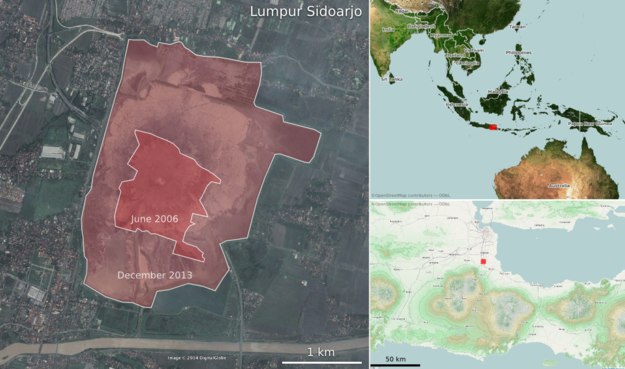
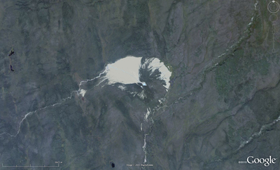
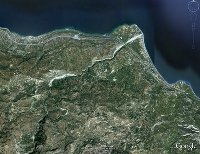
Lusi is the nickname of Lumpur Sidoarjo — 'the mud of Sidoarjo' — the giant mud volcano in the city of Sidoarjo, East Java, Indonesia. This week, Lusi is eight years old.

Google MapsBefore you read on, I recommend taking a look at it in Google Maps. Actually, Google Earth is even better — especially with the historical imagery. 

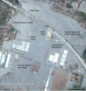
The mud flow was [may have been; see comments below — edit, 26 June 2014] triggered by the Banjar Panji 1 exploration well, operated by Lapindo Brantas, though the conditions may have been set up by a deadly earthquake. Mud loss events started in the early hours of 27 May 2006, seven minutes after the 6.2 Mw Yogyakarta earthquake that killed about 6,000 people. About 24 hours later, a large kick was killed and the blow-out preventer activated. Another 22 hours after this, while fishing in the killed well, mud, steam, and natural gas erupted from a fissure about 200 m southwest of the well. A few weeks after that, it was venting 180,000 m³ every day — enough mud to fill 72 Olympic swimming pools.

Thousands of years

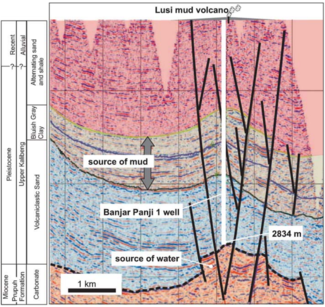
In the slow-motion disaster that followed, as hot water from Miocene carbonates mobilized volcanic mud from Pleistocene mudstones, at least 15,000 people — and maybe as many as 50,000 people — were displaced from their homes. Davies et al. (2011) estimated that the main eruption may last 26 years, though recent sources suggest it is easing quickly. Still, during this time, we might expect 95–475 m of subsidence. And in the long term? 

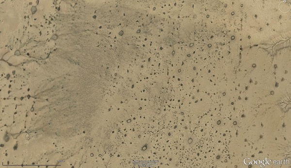
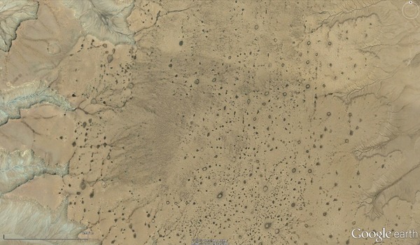
By analogy with natural mud volcanoes it can be expected to continue to flow at lower rates for thousands of years. — Davies et al. (2011)

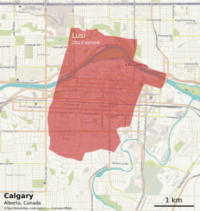
So we're only 8 years into a thousand-year man-made eruption. And there's already enough mud thrown up from the depths to cover downtown Calgary...

References and further reading

Quite a bit has been written about LUSI. The Hot Mud Flow blog tracks a lot of it. The National University of Singapore has a lot of satellite photographs, besides those you'll find in Google Earth. The Wikipedia article links to a lot of information, as you'd expect. The Interweb has a few others, including this article by Tayvis Dunnahoe in E&P Magazine. 

There are also some scholarly articles. These two are worth tracking down:

Davies, R, S Mathias, R Swarbrick and M Tingay (2011). Probabilistic longevity estimate for the LUSI mud volcano, East Java. Journal of the Geological Society 168, 517–523. DOI 10.1144/0016-76492010-129

Sawolo, N, E Sutriono, B Istadi, A Darmoyo (2009). The LUSI mud volcano triggering controversy: was it caused by drilling? Marine & Petroleum Geology 26 (9), 1766–1784. DOI 10.1016/j.marpetgeo.2009.04.002


The satellite images in this post are © DigitalGlobe and Google, captured from Google Earth, and are used here in accordance with their terms of use. The maps are © OpenStreetMap and licensed ODbL. The seismic section is from Davies et al. 2011 and © The Geological Society of London and is used here in accordance with their terms of use. The text of this post is © Agile Geoscience and openly licensed under the terms of CC-BY, as always!

10 days on the Mid-Atlantic Ridge

I have just returned from a 10-day holiday in Iceland, an anomalous above-sea-level bump in the North Atlantic's mid-ocean ridge. It sits over a mantle hotspot at the junction of the ridge and the WNW–ESE volcanic province stretching from the Greenland to the Faroes.

Meteorologically, culinarily, fincancially, Iceland does not score especially highly. But geologically—the only way that really matters—it's the most amazing place I've ever been. And we only visited a few spots (right). Here are some highlights...

Reykjanes. My favourite geological locality was the first place we went, and the most desolate. Barely half-an-hour's drive from the airport, you can go and see the Mid-Atlantic Ridge rise out of the North Atlantic, and start its romp across the country. Reykjanes looks much like you'd expect newborn crust to look: a brutal but pristine landscape of lava, interrupted by clusters of small volcanic cones, elongate fissures, and small grabens. 

Þingvellir. The archetypal rift valley is Þingvellir (Thingvellir), which almost defies description. On top of the textbook geology is a layer of almost magical history — mythical in character, but completely real. For example, you can stand next to the drekkingarhylur (drowning pool), where deviants were executed by drowning, and diligently documented, from about 930 CE onwards. Explorationists know that early rifting is often associated with lacustrine deposits, rapid subsidence, and source rocks. And Iceland's largest lake sits happily in a new (relatively) rift valley, subsiding dutifully since records began. 

Helluhraun (pahoehoe lava) and one of the bounding faults at Þingvellir

Ice. The other thing Iceland has plenty of, apart from lava, is ice. I've seen plenty of glaciers before, and climbed around on a few, but I've never seen them calving icebergs. And I've never seen the products of subglacial eruptions: massive plains of sand dumped by jökulhlaups, and distinctively elongate or flat-topped volcanos.

Icebergs in front of Breiðamerkurjökull

We vowed to return when our youngest, who is only 3 now, is old enough to remember some of it. We mostly stayed in guesthouses, but we decided a camper van is the way to go — there's so much to see. I also realized I need a lot more photographic equipment! And skill.

Wave-particle duality

Geoblogger Brian Romans has declared it Dune Week (here's part of his tweet), so I thought I'd jump on the bandwagon with one of my favourite dynamic dune examples illustrating the manifold controls on dune shape. 

Barchan dunes and parabolic dunes both form where there is limited sand supply and unimodally-directed wind (that is, the wind always blows from the same direction). Barchans, like these in Qatar, migrate downwind as sand is blown around the tips of the crescent. Consequently, the slip face is concave.

Location: 24.98°N, 51.37°E

In contrast, parabolic dunes have a convex slip face. They form in vegetated areas: vegetation causes drag on the arms of the crescent, resulting in the elongated shape. These low-amplitude dunes in NE Brazil have left obvious trails.

Location: 3.41°S, 39.00°W


The eastern edge of White Sands dunefield in New Mexico shows an interesting transition from barchan to parabolic, as the marginal vegetation is encroached upon by these weird gypsum dunes. The mode transition runs more or less north–south. Can you tell which side is which? Which way does the wind blow?

View Larger Map

Herrmann and Duràn modelled this type of transition, among others, in a series of fascinating papers including this presentation and Durán et al  2007, Parabolic dunes in north-eastern Brazil, in arXiv Soft Condensed Matter. Their figures show how their numerical models represent nature quite well as barchans transition to parabolic dunes:

Duran_Herrmann_2006_Dunes.png

Where on (Google) Earth #315

After a long break from this awesome game, I got WoGE #314 by simple recognition. I've never been to Florida, but have scoured the whole region looking for interesting modern analogs. So I have the honour of turning in the next edition; the time is 1100 ADT, 1400 GMT, or 44-07-07 ∇ 14:19:14 Lunar Standard Time. In case you're on the moon.

Where on (Google) Earth is the best way to tour the virtual globe since the mighty View-Master. If you are new to the game, fear not, it is easy to play. The winner is the first person to examine the picture below, find the location (name, link, or lat-long), and give a brief explanation of its geological interest. Please post your answer in the comments. And thanks to the Schott Rule, which I am invoking, newbies have a slight edge: previous winners must wait one earth hour for each win before playing—with a maximum of 48 (yes, some people are quite good at this game).

So: where and what the Dickens is this?

Where on (Google) Earth #272

I got WoGE #271 by the well-established lucky guess method. Some people mightn't think this is a method sensu stricto, but I will take what I can get. So I unabashedly declare victory and bring you number 272, fresh out of the oven; the time is 1600 AST, 2000 GMT.

Where on (Google) Earth is the best way to get a repetitive strain injury since interpreting seismic data. If you are new to the game, it is easy to play. The winner is the first person to examine the picture below, find the location (name, link, or lat-long), and give a brief explanation of its geological interest. Please post your answer in the comments. And thanks to the Schott Rule, which I am invoking, newbies have a slight edge: previous winners must wait one earth hour for each previous win before playing.

So: where and what on Google's green earth is this?

Where on Google Earth #266

Brian nailed Where on Google Earth #265. He doesn't have a blog of his own so he asked me to host it for him. So, over to Brian...

Much thanks go to Matt here for hosting this WoGE for me since I do not yet have a blog of my own. I'm already looking into options. This is just too much fun for a Google Earth addict like me.

Although this image is zoomed in pretty good I'll invoke the Schott Rule just to give newcomers like myself a chance. For those unaware, this means you must wait one hour for each previous WoGE win before you can post your answer. [Here are the previous winners in Ron Schott's KML file — Matt].

I've also hidden the orientation compass so you can safely assume North isn't necessarily at top. Can't make it too easy now, can we?

This one isn't just about the geology, but also the historical significance.

Please post responses in the comments. Posted at 0800 Atlantic, 1200 GMT.

Where on Google Earth #259

I got WoGE #258 by the skin of my teeth, as I found the location but failed to fully identify the feature. I got the country rock right, but the igneous one wrong. As a soft rock chap, I consider this to be a technicality. Luckily, so did Metageologist Simon, the host. So I humbly accept my failings as a geoscientist and offer you the next instalment: number 259, and hereby post it at 1300 AST, 1700 GMT. 

Where on Google Earth is the best use of your lunch-break since Worms Reinforcements (the only computer game I ever wanted to play twice). If you are new to the game, it is easy to play. The winner is the first person to examine the picture below, find the location (name, link, or lat-long), and give a brief explanation of its geological interest. Please post your answer in the comments below. And thanks to the Schott Rule, which I am invoking, newbies have a slight edge: previous winners must wait one hour for each previous win before playing.

So: where and what on Google earth is this? (There are quite a few interesting things here, both geomorphologic and geologic; see how many you can get!)

Where on Google Earth #252

Felix Bossert stumped us with one of the most unusual geomorphologies on the planet with WoGE #251 last week. The  sub-parallel elongate low-sinuosity (OK, wormy) features, reminiscent of a fingerprint, turned out to be the acidic dregs of a salt lake in Western Australia. 

Where on Google Earth, the brilliant brainchild of clasticdetritus, is the best use of satellite imagery since looking at homes and gardens of the rich and famous. If you are new to the game, it is easy to play. The winner is the first person to examine the picture below, find the location (name, link, or lat-long), and give a brief explanation of its geological interest. Please post your answer in the comments. Thanks to the Schott Rule, which I hereby invoke, newbies have a slight edge: previous winners must wait one hour for each previous win before playing.

Where and what on Google's blue earth is this?

Where on Google Earth #249

Elisabeth Kosters, who correctly identified the Bay of Fundy in WoGE #248, asked me to host her challenge for the next instalment. So here we are again. Welcome to WoGE #249.

Where on Google Earth is the best use of a high-speed internet connection since e-journals. If you are new to the game, it is easy to play. The winner is the first person to examine the picture below, find the location (name, link, or lat-long), and give a brief explanation of its geological interest. Please post your answer in the comments below. And thanks to the Schott Rule, which Elisabeth is invoking, newbies have a slight edge: previous winners must wait one hour for each previous win before playing.

So: where and what on Google earth is this?

Where on Google Earth #248

Where on Google Earth is the best use of a coffee break since reading geoblogs. Despite not knowing much about the last one (no-one really knows how mima mounds form, even at Mima Mounds Natural Area, in Washington, USA), I happened to know where it was. So it is my honour, nay duty, to present WoGE #248. 

If you are new to the game, it is easy to play. The winner is the first person to examine the picture below, find the location (name, link, or lat-long), and give a brief explanation of its geological interest. Please post your answer in the comments below. And thanks to the Schott Rule, which I am invoking, newbies have a slight edge: previous winners must wait one hour for each previous win before playing. This seems punitive, given how quickly some WoGE's have been solved recently, but there it is. 

So crack open your favourite virtual globe, and good luck!