Rock physics and steam

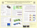
Over the last few weeks, I have been revisiting and reminiscing over some past work, and found this poster I made for the 2007 SEG Development & Production Forum on the geophysics of heavy oil. A few months ago, the organizers of the workshop made a book out of many great articles that followed. Posters, however, often get printed only once, but that doesn't mean they need only be viewed once.

The poster illustrates the majority of my MSc thesis on the rock physics of steam injection in Canadian oil sands. You might be interested in this if you are interested in small scale seismic monitoring experiments, volume visualization, and novel seismic attributes for SAGD projects. For all you geocomputing enthusiasts, you'll recognize that all the figures were made with MathWorks MATLAB (something I hope to blog about later). It was a fun project, because it merged disparate data types, rock physics, finite-difference modeling, time-lapse seismic, and production engineering. There are a ton of subsurface problems that still need to be solved in oil sands, many opportunities to work across disciplines, and challenge the limits of our geoscience creativity. 

Here's the full reference: Bianco, E & D Schmitt (2007). High resolution modeling and monitoring of the SAGD process at the Athabasca tar sands: Underground Test Facility (UTF), 2007 SEG D&P Forum, Edmonton, Canada. If you prefer, you can grab these slides which I gave as an oral presentation on the same material, or flip to chapter 6 in the book.

Where on Google Earth #249

Elisabeth Kosters, who correctly identified the Bay of Fundy in WoGE #248, asked me to host her challenge for the next instalment. So here we are again. Welcome to WoGE #249.

Where on Google Earth is the best use of a high-speed internet connection since e-journals. If you are new to the game, it is easy to play. The winner is the first person to examine the picture below, find the location (name, link, or lat-long), and give a brief explanation of its geological interest. Please post your answer in the comments below. And thanks to the Schott Rule, which Elisabeth is invoking, newbies have a slight edge: previous winners must wait one hour for each previous win before playing.

So: where and what on Google earth is this?

Create better time scales

If you ever find yourself drawing geological time scales in Microsoft PowerPoint (embarrassingly enough, this has happened to me), or trying to build a hackish database of geological events in Microsoft Excel, then you need TimeScale Creator. This free, Java-based application runs on any platform (because it's Java), and is fully extensible with your own stratigraphic data. You can also buy a Pro version ($500 for non-commerical use, or $1500 for commercial purposes). The upgrade gets you various stratigraphic data packs and other perks like better export functionality. 

To give you a flavour of what this little app can do, I made a quick column for part of the Palaeogene. I picked the interval more or less at random, and haven't changed any of the defaults except the columns to display, but this took me about 60 seconds to make. The data I'm showing here are all included in the free version, and all ratified by the International Commission on Stratigraphy. And I can export it as an SVG file (scalable vector graphics), which I can edit freely in Inkscape or any of several other vector graphics editors. applications. Here it is:

You can download the software by following this link. If you have any tips for using the software, or other ways to make timescales, please leave them in the comments!

Note, TimeScale Creator is a trademark of the Geologic TimeScale Foundation. I am not connected with the software or its creators in any way. Microsoft PowerPoint and Excel are trademarks of Microsoft Corporation. Java is a trademark of Oracle Corporation.

Where on Google Earth #248

Where on Google Earth is the best use of a coffee break since reading geoblogs. Despite not knowing much about the last one (no-one really knows how mima mounds form, even at Mima Mounds Natural Area, in Washington, USA), I happened to know where it was. So it is my honour, nay duty, to present WoGE #248. 

If you are new to the game, it is easy to play. The winner is the first person to examine the picture below, find the location (name, link, or lat-long), and give a brief explanation of its geological interest. Please post your answer in the comments below. And thanks to the Schott Rule, which I am invoking, newbies have a slight edge: previous winners must wait one hour for each previous win before playing. This seems punitive, given how quickly some WoGE's have been solved recently, but there it is. 

So crack open your favourite virtual globe, and good luck!

The integration gap

Agile teams have lots of ways to be integrated. They need to be socially integrated: they need to talk to each other, know what team-mates are working on, and have lots of connections to other agile teams and individuals. They need to be actively integrated: their workflows must complement one another's. If the geologist is working on new bulk density curves, the geophysicist uses those curves for the synthetic seismograms; if the geophysicist tweaks the seismic inversion result, the geomodeller uses that volume for the porosity distribution.

But the agile team also needs to be empirically integrated: the various datasets need to overlap somehow so they can be mutually calibrated and correlated. But if we think about the resolution of subsurface data, both spatially, in the (x,y) plane, and vertically, on the z axis, we reveal a problem—the integration gap.

Scales_of_measurement.png

This picks up again on scale (see previous post). Geophysical data is relatively low-resolution: we can learn all about large, thick features. But we know nothing about small things, about a metre in size, say. Conversely, well-based data can tell us lots about small things, even very small things indeed. A vertical well can tell us about thick things, but not spatially extensive things. A horizontal well can tell us a bit more about spatially large things, but not about thick things. And in between this small-scale well data and the large-scale seismic data? A gap. 

This little gap is responsible for much of the uncertainty we encounter in the subsurface. It is where the all-important well-tie lives. It leads to silos, un-integrated behaviour, and dysfunctional teams. And it's where all the fun is!

† I've never thought about it before, but there doesn't seem to be an adjectival form of the word 'data'. 


UPDATE This figure was updated later:

Scales_of_measurement_complete.png

Will this change anything?

Stubborn as it is, I often neglect to check the weather forecast before I go out in the morning. I live within walking distance to most things, and I can bear extreme cold for a few minutes (and even run if I have to). So for me, searching for a weather forecast the night before or the first thing won't actually change my morning routine. And that is to say nothing of the reliability of the forecasts!

Every one of us can pick and choose how much information to use in our daily lives. On one end of the spectrum is no information, where uncertainty and ambiguity reigns. On the other end is total information, which can be unwieldy and noisy. One way to hone in the appropriate balance is to ask the question, "will this change anything?"

When deciding whether to run a fancy diagnostic borehole tool, say, or to redo a structure map to include new well data, the wrong thing to ask is "what will this information do for me?", or even, "will this technology or method work?" Instead, we should be asking, "will this change anything?" 

Will adding (or excluding) this ingredient change the taste or outcome of my meal?

If the drilling engineer on your team is on the ball, cost conscious, and able to drill at 40 metres per hour, then LWD (logging-while-drilling) information may not actually allow you to steer the well on the fly. It's nice data to have after the fact, but it won't change how you drill the well. If your team's strategy is to drill relative time structural highs, then re-doing a velocity model for more accurate depth maps may be a waste of time. 

When we talk about how information might change our plans, or change our understanding, we are talking about it's value.  Asking, "will this change anything?" is really trying to pin down, "how much do I value this information?" The weather channel might be more valuable to you than it is to me, but how valuable is it? Will it change anything if you have to get on without it?

Ripples

Yesterday I visited Sand Dollar Beach, near Lunenburg, with the kids. There's lots of room to run around: the beach has a 400 m wide foreshore, which means lots of shallow water at high tide (as in the Google Maps picture here). The low angle (less than half a degree) also sees the tide go in and out very quickly, allowing little time for reworking the delicate ripples. Their preservation is further helped by the fact that the waves along this sheltered coast are typically low-amplitude.


View Larger Map

At the edge of the just-visible stream cutting through the beach, the regular wave ripples, produced by oscillating currents, morph into more chaotic linguiod current ripples (right-hand side, mostly obscured by the stream). I can't say for sure, but the pattern may have been modified by animal tracks (deer, dog, dude?) during some previous low tide.

As I posted before, I am interested in the persistence of patterns across scales and even processes. For instance, this view (right) reminded me of blogger Silver Fox's recent post about the Basin and Range caterpillar army. An entirely different process: parallel morpholution.

If you look closely at the Google Map, above, you can see dim duneforms in the shallows, as a series of sub-parallel dark stripes. They echo the ripples in orientation and process, but have a wavelength of about 30 m. If you can't see them maybe this annotated version will help.

I would not claim to be an expert in the feeding traces of invertebrates, but I love taking pictures of them. I think the animals grazing in the cusps of these ripples were Chiridotea coeca, a tiny crustacean. You can read (a lot) more about them in Hauck et al (2008), Palaios 23, 336–343. According to these authors, such trails may be modern analogs of a rather common trace fossil called Nereites

Adding another author to Agile*

A pediatrician, a scuba diver, and a geophysicist walk into a bar . . .

Sounds like the start of a great joke, but actually, it will be the story of my first blog entry. The last time I had to describe my career to someone, it was in a completely different context. The week Matt moved to Nova Scotia, my wife and I were scrambling to get our scuba diving certification so we could dive the reefs of Mozambique. One of my best friends was getting married in South Africa and diving was one of the must-do activities on our trip.

Getting to the dive camp in the gentle beach settlement of Ponta Malongane was a mission. Crossing the border from the familiar and relatively cosmopolitan townships of South Africa into Mozambique was like shaking off the anaesthetic of an already waning familiarity. We watched entourage after entourage of vacationing South Africans in beach shorts creep their vehicles 25 metres beyond the mobile trailers and chain link fence that comprised an otherwise unrecognizable border post. Methodically, they would turn up the radio, as to celebrate their clearance into the country, take out the gauge and drop the tire pressure down to 0.8 bar.

A common conversation about driving to Mozambique starts like this...

“Evan, do you have a 4-by-4?”
“Yes.” We were lucky enough to borrow the groom's.
“How many spare tyres do you have?”
“Er, one, . . . just one”
“Oh, well, . . . you might be alright.”
Read More

Unsolved problems

One of the recurring dreams I've had this year is about unsolved problems. I've always loved these lists, the best known of which is perhaps the German David Hilbert's 1900 list of 23 unsolved problems in mathematics. There are several published versions of the list; take look at a later manuscript describing some of the problems.

A year or two ago, I read this meta-list in Wikipedia. Natch, I immediately wanted to create a list of unsolved problems in geoscience. It could help researches find big, interesting problems. It could help software developers focus their talents. It might just be a bit of fun. However, articles in Wikipedia need something to reference[citation needed], so even if I were capable of such a thing, one can't just sit down and hack one out. 

But you can try. Earlier this year, I drafted a proto-list for geophysics, drawn mostly from chats with friends. Please feel free to vote on the list, or add problems of your own. It is, I admit, a bit biased towards problems in seismology in pursuit of hydrocarbons. The list should be much broader, but I'm not yet the polymath I strive to be and quickly get out of my depth!

Here are the top five (per today) from my Google Moderator list of unsolved problems in geophysics:

  • How can we represent and quantify error and uncertainty from acquisition, through processing and interpretation, to analysis?
  • What useful signal or information can we extract from what we usually call 'noise' (multiples, refractions, reverberations, etc)?
  • How can we exploit the full spectrum in acquisition, processing, interpretation, and analysis?
  • Is there a 'best practice' for tying wells; if so, what is it?
  • What exactly is AVO-friendly processing?

What might a list of unsolved problems in geology look like? My likely-ignorant outlook suggests some:

  • Is it possible to predict the location, severity, and/or timing of earthquakes?
  • Do mantle plumes exist?
  • How do magnetic reversals happen?
  • Are mass extinctions cyclic?
  • Do the earth's physico-chemical systems mostly drive, or mostly respond to, changes in climate?
  • Does eustatic (global, synchronous, uniform) sea-level change happen, or does the ubiquity of local tectonism obviate the concept?
  • What exactly was the sequence of events that resulted in the end-Permian extinction? The end-Cretaceous?

I am proposing a workshop on the topic of unsolved problems in exploration and development geophysics at SEG next year in San Antonio. Ideas welcome.

Setting up shop

My family and I finally moved into our new old house on Sunday. We are slowly gaining the upper hand in the battle of the boxes. The kids have got some of their toys back and are finding their way around the place. I can find most things by looking in only about three cupboards. 

And my new office is almost finished. The last occupant of this place was a boat-builder, and he had a great workshop in the back yard (see pic). I would love to have kept it as-is, but a couple of days of trying to work in the house made it clear that I need a workspace outside the house. 

So I've partitioned off half the space, added a long landscape window, and a floor, and a built-in desk, and it should be comfortable enough to work in for a few months at least, maybe even years.

Even starting with some constraints, it was surprisingly hard to put my finger on exactly what would make my ideal workspace. Here are some of the things I decided I wanted, in no particular order:

  • Some sort of view
  • Natural light, ideally from a north-facing skylight
  • A long desk with no cable clutter
  • Plenty of space to tidy hard drives, printers, routers, etc.
  • Plenty of space for books and papers
  • Somewhere comfortable to sit and read
  • Somewhere to work on non-computery stuff (like another desk)
  • A wood-burning stove
  • A kitchenette and a toilet

The skylight, stove, and sanitation will have to wait, but I think I got most of the rest checked. I'll post a follow-up when it's nearing completion.