Open source FWI, I mean geoscience

I'm being a little cheeky. Yesterday's Open Source Geoscience workshop at EAGE was not really only about full waveform inversion (FWI). True, it was mostly about geophysics, but there was quite a bit of new stuff too.

But there was quite a bit on FWI.

The session echoed previous EAGE sessions on the same subject in 2006 and 2012, and was chaired by Filippo Broggini (of ETH Zürich), Sergey Fomel (University of Texas), Thomas Günther (LIAG Hannover), and Russell Hewett (Total, unfortunately not present). It started with a look at core projects like Madagascar and OpendTect. There were some (for me) pretty hard core, mathematics-heavy contributions. And we got a tour of some new and newish projects that are seeking users and/or contributors. Rather than attempting to cover everything, I'm going to exercise my (biased and ill-gotten) judgment and focus on some highlights from the day.

Filippo Broggini started by reminding us of why Joe Dellinger (BP) started this recurrent workshop a decade ago. Here's how Joe framed the value of open source to our community:

The economic benefits of a collaborative open-source exploration and production processing and research software environment would be enormous. Skilled geophysicists could spend more of their time doing innovative geophysics instead of mediocre computer science. Technical advances could be quickly shared and reproduced instead of laboriously re-invented and reverse-engineered. Oil companies, contractors, academics, and individuals would all benefit.

Did I mention that he wrote that 10 years ago?

Lessons learned from the core projects

Kristofer Tingdahl (dGB) then gave the view from his role as CEO of dGB Earth Sciences, the company behind OpendTect, the free and open source geoscience interpretation tool. He did a great job of balancing the good (their thousands of users, and their SEG Distinguished Achievement Award 2016) with the less good (the difficulty of building a developer community, and the struggle to get beyond only hundreds of paying users). His great optimism and natural business instinct filled us all with hope.

The irrepressible Sergey Fomel summed up 10 years of Madagascar's rise. In the journey from v0.9 to v2.0, the projects has moved from SourceForge to GitHub, gone from 6 to 72 developers, jumped from 30 to 260 reproducible papers, and been downloaded over 40 000 times. He also shared the story of his graduate experience at Stanford, where he was involved in building the first 'reproducible science' system with Jon Claerbout in the early 1990s. Un/fortunately, it turned out to be unreproducible, so he had to build Madagascar.

It's not (yet?) a core project, but John Stockwell (Colorado School of Mines) talked about OpenSeaSeis and barely mentioned SeismicUnix. This excellent little seismic processing project is now owned by CSM, after its creator, Bjoern Olofsson, had to give it up when he went to work for a corporation (makes sense, right? o_O ). The tool includes SeaView, a standalone SEGY viewer, as well as a graphical processing flow composer called XSeaSeis. IT prides itself on its uber-simple architecture (below). Want a gain step? Write gain.so and you're done. Perfect for beginners.

Jeffrey Shragge (UWA), Bob Clapp (SEP), and Bill Symes (Rice) provided some perspective from groups solving big math problems with big computers. Jeff talked about coaxing Madgascar — or M8R as the cool kids apparently refer to it — into the cloud, where it can chomp through 100 million core hours without setting tings on fire. This is a way for small enterprises and small (underfunded) research teams to get big things done. Bob told us about a nifty-looking HTML5 viewer for subsurface data... which I can't find anywhere. And Bill talked about 'mathematical fidelty'. and its application to solving large, expensive problems without creating a lot of intermediate data. His message: the mathematics should provide the API.

New open source tools in geoscience

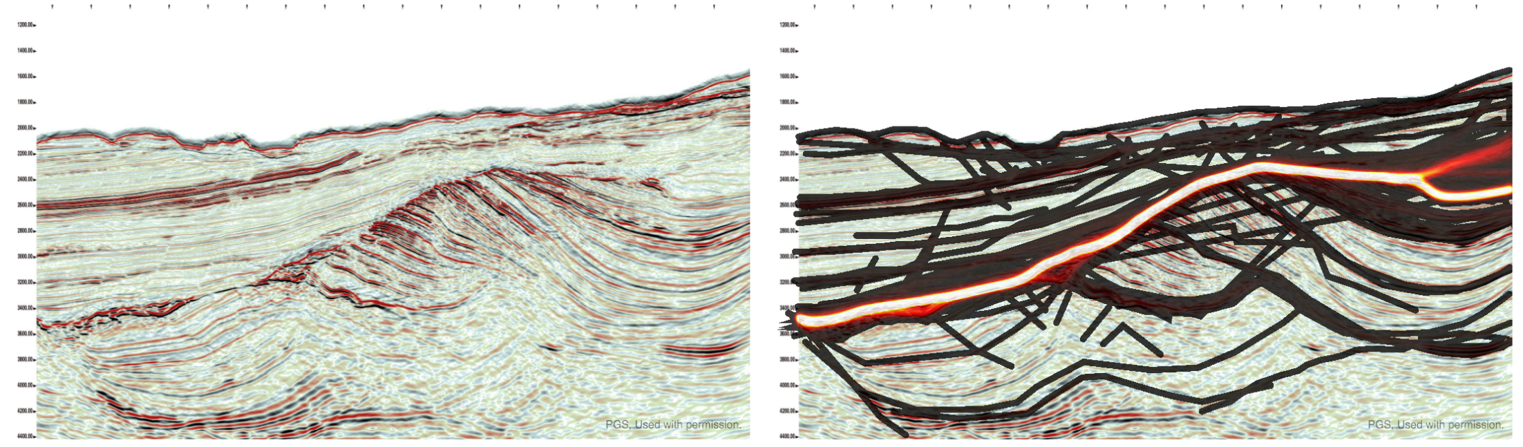
The standout of the afternoon for me was University of Vienna post-doc Eun Young Lee's talk about BasinVis. The only MATLAB code we saw — so not truly open source, though it might be adapted to GNU Octave — and the only strictly geological package of the day. To support her research, Eun Young has built a MATLAB application for basin analysis, complete with a GUI and some nice visuals. This one shows a geological surface, gridded in the tool, with a thickness map projected onto the 'floor' of the scene:

I'm poorly equipped to write much about the other projects we heard about. For the record and to save you a click, here's the list [with notes] from my 'look ahead' post:

  • SES3D [presented by Alexey Gokhberg], a package from ETHZ for seismic modeling and inversion.
  • OpenFOAM [Gérald Debenest], a new open source toolbox for fluid mechanics.
  • PyGIMLi [Carsten Rücker], a geophysical modeling and inversion package.
  • PySIT [Laurent Demanet], the Python seismic imaging toolbox that Russell Hewett started while at MIT.
  • Seismic.jl [Nasser Kazemi] and jInv [Eldad Haber], two [modeling and inversion] Julia packages.

My perception is that there is a substantial amount of overlap between all of these packages except OpenFOAM. If you're into FWI you're spoilt for choice. Several of these projects are at the heart of industry consortiums, so it's a way for corporations to sponsor open source projects, which is awesome. However, most of them said they have closed-source components which only the consortium members get access to, so clearly the messaging around open source — the point being to accelerate innovation, reduce bugs, and increase value for everyone — is missing somewhere. There's still this idea that secrecy begets advantage begets profit, but this idea is wrong. Hopefully the other stuff, which may or may not be awesome, gets out eventually.


I gave a talk at the end of the day, about ways I think we can get better at this 'openness' thing, whatever it is. I will write about that some time soon, but in the meantime you're welcome to see my slides here.

Finally, a little time — two half-hour slots — was set aside for discussion. I'll have a go at summing that up in another post. Stay tuned!

BasinVis image © 2016 Eun Young Lee, used with permission. OpenSeaSeis image © 2016 Center for Wave Phenomena

READY PLAYER 1

The Subsurface Hackathon 2016 is over! Seventeen hackers gathered for the weekend at Impact HUB Vienna — an awesome venue and coworking space — and built geoscience-based games. I think it was the first geoscience hackathon in Europe, and I know it was the first time a bunch of geoscientists have tried to build games for each other in a weekend.

What went on 

The format of the event was the same as previous events: gather on Saturday, imagine up some projects, start building them by about 11 am, and work on them until Sunday at 4. Then some demos and a celebration of how amazingly well things worked out. All interspersed with coffee, food, and some socializing. And a few involuntary whoops of success.

What we made

The projects were all wonderful, but in different ways. Here's a quick look at what people built:

  • Trap-tris — a group of lively students from the University of Leeds and the Technical University of Denmark built a version of Tetris that creates a dynamic basin model. 
  • Flappy Seismic — another University of Leeds student, one from Imperial College, and a developer from Roxar, built a Flappy Bird inspired seismic interpretation game.
  • DiamonChaser (sic) — a team of devs from Giga Infosystems in Freiberg built a very cool drilling simulation game (from a real geomodel) aimed at young people.
  • Guess What — a developer from Spain and two students from UNICAMP in Brazil built a 'guess the reflection coefficient' game for inverting seismic.

I will write up the projects properly in a week or two (this time I promise :) so you can see some screenshots and links to repos and so on... but for now here are some more pictures of the event.

The fun this year was generously sponsored by EMC. David Holmes, the company's CTO (Energy), spent his weekend hanging out at the venue, graciously mentoring the teams and helping to provide some perspective or context, and help carrying pizza boxes through the streets of Vienna, when it was needed.


Click on the hackathon tag below to read about previous hackathons

Look ahead to EAGE 2016

I'm in Vienna for the 78th EAGE Conference and Exhibition, at Wien Messe, starting on Sunday. And, of course, for the Subsurface Hackathon, which I've already mentioned a few times. 

The hackathon, is, as usual, over the weekend. It starts tomorrow, in this amazing coworking space. That's @JesperDramsch there, getting ready for the hackathon!

I know this doesn't suit everyone, but weekdays don't suit everyone either. I've also always wanted to get people out of 'work mode', into the idea that they can create whatever they want. Maybe we'll try one during the week some time; do let me know what you think about it in the comments. Feedback helps.

Don't worry, you will hear more about the hackathon. Stay tuned.

Open source software in applied geosciences

The first conference event I'll be at is the workshop on open source software. This follows up on similar get-togethers in Copenhagen in 2012 and in Vienna in 2006. I hope the fact that the inter-workshop interval is getting shorter is a sign that open source geoscience software is gaining traction!

The workshop is being organized by Filippo Broggini (of ETH Zürich), Sergey Fomel (University of Texas), Thomas Günther (LIAG Hannover), and Russell Hewett (Total). They have put together a great-looking program. In the morning, Kristofer Tingdahl (CEO of dGB Earth Sciences) will talk about business models for open source. Then Sergey Fomel will update us on Madagascar seismic processing toolbox. Finally, in a series of talks, Jeff Shragge (Univ. Western Australia), Bob Clapp (Stanford), and Bill Symes (Rice) will talk about using Madagascar and other geophysical imaging and inversion tools at a large scale and in parallel.

After lunch, there's a veritable parade of updates and new stuff, with all of these projects checking in:

  • OpenSeaSeis, which raised a lot of eyebrows in 2012 for its general awesomeness. Now a project at Colorado School of Mines.
  • SES3D, a package from ETHZ for seismic waveform modeling and inversion.
  • BasinVis, a MATLAB program for modeling basin fill and subsidence (woo! Open source geology!!)
  • OpenFOAM, a new open source toolbox for fluid mechanics.
  • PyGIMLi, a geophysical modeling and inversion package.
  • PySIT, the Python seismic imaging toolbox that Russell Hewett started while at MIT.
  • Seismic.jl and jInv (that's j-inv), two Julia packages you need to know about.

Aaaand at the very end of the day, is a talk from your truly on 'stuff we can do to get more open source goodness in geoscience'. I'll post some version of the talk here when I can.

Talks and stuff

I don't have any plans for Tuesday and Wednesday, other than taking in some talks and posters. I'm missing Thursday. Picking talks is hard, especially when there are 15 (yup) parallel sessions,... and that's just the oral presentations. (Hey! Conference organizer people! That's crazy!) These conference apps that get ever-so-slightly-better each year won't be really useful until they include a recommendation engine of some sort. I'd like two kinds of recommendation: "stuff that's aligned with my interests but you will disagree with everyone in there", and "stuff that doesn't seem to be aligned with my interests, but maybe it really is".

Oh and also "stuff that isn't too far away from the room I'm in right now because I only have 80 seconds to get there".

Anyway, I haven't chosen my sessions yet, let alone started to trawl through the talk titles. You can probably guess the session titles — Carbonate Petrophysics, Multiple Attenuation, Optimizing Full Waveform Marine Acquisition for Quantitative Exploration II (just kidding).

There are some special sessions I may seek out. There's one for professional women in geoscience and engineering, and two for young professionals, one of which is a panel discussion. Then there are two 'dedicated sessions': Integrated Data for Geological and Reservoir Models, and Towards Exascale Geophysical Applications, which sounds intriguing... but their programmes look like the usual strings of talks, so I'm not sure why they're singled out. There's also something called EAGE Forum, but I can't tell what that is.


Arbitrary base 10 milestone!

I don't pay as much attention to blog stats as I used to, but there is one number that I've been keeping an eye on lately: the number of posts. This humble little post is the 500th on this blog! Kind of amazing, though I'm not sure what it says about me and Evan, in terms of making sound decisions about how we spend our evenings. I mean, if each post is 600 words,... that's two good-sized novels!

I'm not saying they're good novels...

The images of the Impact HUB Vienna that don't have Jesper in them are CC-BY-SA by the HUB.

ORCL vs GOOG: the $9 billion API

What's this? Two posts about the legal intricacies of copyright in the space of a fortnight? Before you unsubscribe from this definitely-not-a-law-blog, please read on because the case of Oracle America, Inc vs Google, Inc is no ordinary copyright fight. For a start, the damages sought by Oracle in this case [edit: could] exceed $9 billion. And if they win, all hell is going to break loose.

The case is interesting for some other reasons besides the money and the hell breaking loose thing. I'm mostly interested in it because it's about open source software. Specifically, it's about Android, Google's open source mobile operating system. The claim is that the developers of Android copied 37 application programming interfaces, or APIs, from the Java software environment that Sun released in 1995 and Oracle acquired in its $7.4 billion acquisition of Sun in 2010. There were also claims that they copied specific code, not just the interface the code presents to the user, but it's the API bit that's interesting.

What's an API then?

You might think of software in terms of applications like the browser you're reading this in, or the seismic interpretation package you use. But this is just one, very high-level, type of software. Other, much lower-level software runs your microwave. Developers use software to build software; these middle levels contain FORTRAN libraries for tasks like signal processing, tools for making windows and menus appear, and still others for drawing, or checking spelling, or drawing shapes. You can think of an API like a user interface for programmers. Where the user interface in a desktop application might have menus and dialog boxes, the interface for a library has classes and methods — pieces of code that hold data or perform tasks. A good API can be a pleasure to use. A bad API can make grown programmers cry. Or at least make them write a new library.

The Android developers didn't think the Java API was bad. In fact, they loved it. They tried to license it from Sun in 2007 and, when Sun was bought by Oracle, from Oracle. When this didn't work out, they locked themselves in a 'cleanroom' and wrote a runtime environment called Dalvik. It implemented the same API as the Java Virtual Machine, but with new code. The question is: does Oracle own the interface — the method names and syntaxes? Are APIs copyrightable?

I thought this case ended years ago?

It did. Google already won the argument once, on 31 May 2012, when the court held that APIs are "a system or method of operations" and therefore not copyrightable. Here's the conclusion of that ruling:

The original 2012 holding that Google did not violate the copyright Act by copying 37 of Java's interfaces. Click for the full PDF.

The original 2012 holding that Google did not violate the copyright Act by copying 37 of Java's interfaces. Click for the full PDF.

But it went to the Federal Circuit Court of Appeals, Google's petition for 'fair use' was denied, and the decision was sent back to the district court for a jury trial to decide on Google's defence. So now the decision will be made by 10 ordinary citizens... none of whom know anything about programming. (There was a computer scientist in the pool, but Oracle sent him home. It's okay --- Google sent a free-software hater packing.)

This snippet from one of my favourite podcasts, Leo Laporte's Triangulation, is worth watching. Leo is interviewing James Gosling, the creator of Java, who was involved in some of the early legal discovery process...

Why do we care about this?

The problem with all this is that, when it come to open source software and the Internet, APIs make the world go round. As the Electronic Frontier Foundation argued on behalf of 77 computer scientists (including Alan Kay, Vint Cerf, Hal Abelson, Ray Kurzweil, Guido van Rossum, and Peter Norvig, ) in its amicus brief for the Supreme Court... we need uncopyrightable interfaces to get computers to cooperate. This is what drove the personal computer explosion of the 1980s, the Internet explosion of the 1990s, and the cloud computing explosion of the 2000s, and most people seem to think those were awesome. The current bot explosion also depends on APIs, but the jury is out (lol) on how awesome that one is.

The trial continues. Google concluded its case yesterday, and Oracle called its first witness, co-CEO Safra Catz. "We did not buy Sun to file this lawsuit," she said. Reassuring, but if they win there's going to be a lot of that going around. A lot.

For a much more in-depth look at the story behind the trial, this epic article by Sarah Jeong is awesome. Follow the rest of the events over the next few days on Ars Technica, Twitter, or wherever you get your news. Meanwhile on Agile*, we will return to normal geophysical programming, I promise :)


ADDENDUM on 26 May 2016... Google won the case with the "fair use" argument. So the appeal court's decision that APIs are copyrightable stands, but the jury were persuaded that this particular instance qualified as fair use. Oracle will appeal.

Copyright and seismic data

Seismic company GSI has sued a lot of organizations recently for sharing its copyrighted seismic data, undermining its business. A recent court decision found that seismic data is indeed copyrightable, but Canadian petroleum regulations can override the copyright. This allows data to be disclosed by the regulator and copied by others — made public, effectively.


Seismic data is not like other data

Data is uncopyrightable. Like facts and ideas, data is considered objective, uncreative — too cold to copyright. But in an important ruling last month, the Honourable Madam Justice Eidsvik established at the Alberta Court of the Queen's Bench that seismic data is not like ordinary data. According to this ruling:


...the creation of field and processed [seismic] data requires the exercise of sufficient skill and judgment of the seismic crew and processors to satisfy the requirements of [copyrightability].


These requirements were established in the case of accounting firm CCH Canadian Limited vs The Law Society of Upper Canada (2004) in the Supreme Court of Canada. Quoting from that ruling:


What is required to attract copyright protection in the expression of an idea is an exercise of skill and judgment. By skill, I mean the use of one’s knowledge, developed aptitude or practised ability in producing the work. By judgment, I mean the use of one’s capacity for discernment or ability to form an opinion or evaluation by comparing different possible options in producing the work.


Interestingly:


There exist no cases expressly deciding whether Seismic Data is copyrightable under the American Copyright Act [in the US].


Fortunately, Justice Eidsvik added this remark to her ruling — just in case there was any doubt:


I agree that the rocks at the bottom of the sea are not copyrightable.

It's really worth reading through some of the ruling, especially sections 7 and 8, entitled Ideas and facts are not protected and Trivial and purely mechanical respectively. 

Why are we arguing about this?

This recent ruling about seismic data was the result of an action brought by Geophysical Service Incorporated against pretty much anyone they could accuse of infringing their rights in their offshore seismic data, by sharing it or copying it in some way. Specifically, the claim was that data they had been required to submit to regulators like the C-NLOPB and the C-NSOPB was improperly shared, undermining its business of shooting seismic data on spec.

You may not have heard of GSI, but the company has a rich history as a technical and business innovator. The company was the precursor to Texas Instruments, a huge player in the early development of computing hardware — seismic processing was the 'big data' of its time. GSI still owns the largest offshore seismic dataset in Canada. Recently, however, the company seems to have focused entirely on litigation.

The Calgary company brought more than 25 lawsuits in Alberta alone against corporations, petroleum boards, and others. There have been other actions in other jurisdictions. This ruling is just the latest one; here's the full list of defendants in this particular suit (there were only 25, but some were multiple entities):

  • Devon Canada Corporation
  • Statoil Canada Ltd.
  • Anadarko Petroleum Corporation
  • Anadarko US Offshore Corporation
  • NWest Energy Corp.
  • Shoal Point Energy Ltd.
  • Vulcan Minerals Inc.
  • Corridor Resources Inc.
  • CalWest Printing and Reproductions
  • Arcis Seismic Solutions Corp.
  • Exploration Geosciences (UK) Limited
  • Lynx Canada Information Systems Ltd.
  • Olympic Seismic Ltd.
  • Canadian Discovery Ltd.
  • Jebco Seismic UK Limited
  • Jebco Seismic (Canada) Company
  • Jebco Seismic, LP
  • Jebco/Sei Partnership LLC
  • Encana Corporation
  • ExxonMobil Canada Ltd.
  • Imperial Oil Limited
  • Plains Midstream Canada ULC
  • BP Canada Energy Group ULC
  • Total S.A.
  • Total E&P Canada Ltd.
  • Edison S.P.A.
  • Edison International S.P.A.
  • ConocoPhillips Canada Resources Corp.
  • Canadian Natural Resources Limited
  • MGM Energy Corp
  • Husky Oil Limited
  • Husky Oil Operations Limited
  • Nalcor Energy – Oil and Gas Inc.
  • Suncor Energy Inc.
  • Murphy Oil Company Ltd.
  • Devon ARL Corporation

Why did people share the data?

According to Section 101 Disclosure of Information of the Canada Petroleum Resources Act (1985) , geophysical data should be released to regulators — and thus, effectively, the public — five years after acquisition:


(2) Subject to this section, information or documentation is privileged if it is provided for the purposes of this Act [...]
(2.1) Subject to this section, information or documentation that is privileged under subsection 2 shall not knowingly be disclosed without the consent in writing of the person who provided it, except for the purposes of the administration or enforcement of this Act [...]

(7) Subsection 2 does not apply in respect of the following classes of information or documentation obtained as a result of carrying on a work or activity that is authorized under the Canada Oil and Gas Operations Act, namely, information or documentation in respect of

(d) geological work or geophysical work performed on or in relation to any frontier lands,
    (i) in the case of a well site seabed survey [...], or
    (ii) in any other case, after the expiration of five years following the date of completion of the work;


As far as I can tell, this does not necessarily happen, by the way. There seems to be a great deal of confusion in Canada about what 'seismic data' actually is — companies submit paper versions, sometimes with poor processing, or perhaps only every 10th line of a 3D. But the Canada Oil and Gas Geophysical Operations Regulations are quite clear. This is from the extensive and pretty explicit 'Final Report' requirements: 


(j) a fully processed, migrated seismic section for each seismic line recorded and, in the case of a 3-D survey, each line generated from the 3-D data set;


The intent is quite clear: the regulators are entitled to the stacked, migrated data. The full list is worth reading, it covers a large amount of data. If this is enforced, it is not very rigorous. If these datasets ever make it into the hands of the regulators, and I doubt it ever all does, then it's still subject to the haphazard data management practices that this industry has ubiquitously adopted.

GSI argued that 'disclosure', as set out in Section 101 of the Act, does not imply the right to copy, but the court was unmoved:


Nonetheless, I agree with the Defendants that [Section 101] read in its entirety does not make sense unless it is interpreted to mean that permission to disclose without consent after the expiry of the 5 year period [...] must include the ability to copy the information. In effect, permission to access and copy the information is part of the right to disclose.


So this is the heart of the matter: the seismic data was owned and copyrighted by GSI, but the regulations specify that seismic data must be submitted to regulators, and that they can disclose that data to others. There's obvious conflict between these ideas, so which one prevails? 

The decision

There is a principle in law called Generalia Specialibus Non Derogant. Quoting from another case involving GSI:


Where two provisions are in conflict and one of them deals specifically with the matter in question while the other is of more general application, the conflict may be avoided by applying the specific provision to the exclusion of the more general one. The specific prevails over the more general: it does not matter which was enacted first.


Quoting again from the recent ruling in GSI vs Encana et al.:


Parliament was aware of the commercial value of seismic data and attempted to take this into consideration in its legislative drafting. The considerations balanced in this regard are the same as those found in the Copyright Act, i.e. the rights of the creator versus the rights of the public to access data. To the extent that GSI feels that this policy is misplaced, its rights are political ones – it is not for this Court to change the intent of Parliament, unfair as it may be to GSI’s interests.


Finally:


[...the Regulatory Regime] is a complete answer to the suggestion that the Boards acted unlawfully in disclosing the information and documentation to the public. The Regulatory Regime is also a complete answer to whether the copying companies and organizations were entitled to receive and copy the information and documentation for customers. For the oil companies, it establishes that there is nothing unlawful about accessing or copying the information from the Boards [...]


So that's it: the data was copyright, but the regulations override the copyright, effectively. The regulations were legal, and — while GSI might find the result unfair — it must operate under them. 

The decision must be another step towards the end of this ugly matter. Maybe it's the end. I'm sure those (non-lawyers) involved can't wait for it to be over. I hope GSI finds a way back to its technical core and becomes a great company again. And I hope the regulators find ways to better live up to the fundamental idea behind releasing data in the first place: that the availability of the data to the public should promote better science and better decisions for Canada's offshore. As things stand today, the whole issue of 'public subsurface data' in Canada is, frankly, a mess.

Pick This again, again

Today we're proud to be launching the latest, all new iteration of Pick This!

Last June I told you about some new features we'd added to our social image interpretation tool. This new release is not really about features, but more about architecture. Late in 2015, we were challenged by BG Group, a UK energy company, to port the app to Amazon's cloud (AWS), so that they could run it in their own environment. Once we'd done that, we brought the data over from Google — where it was hosted — and set up the new public site on AWS. It will be much easier for us to add new features to this version.

One notable feature is that you no longer have to have a Google account to log in! This may have been a show-stopper for some people.

The app has been completely re-written from scratch, so there are a few differences. But fundamentally it's the same as before — you can ask your peers questions about images, and they can draw their answers. For example, Don Herron's "Where's the unconformity?" now has over 450 interpretations!

As we improve the tool over the coming weeks, we'll add ways to filter the results down, to attenuate some of the 'interpretation noise'. It's interesting to think about ways to represent this result — what is the 'true interpretation'? Is it the cloud of all opinions? Is there one answer?

Click here to visit the new site. For now it only plays nicely on a desktop computer (mobile is such a headache, but we will get there!). But you should be able to log in, interpret images, and upload new ones. You can let me know about bugs, or tweet @nowpickthis. If you like it, and I really hope you do, please tell your friends!


A quick reminder about the hackathon in Vienna next month. It will be an intense weekend of learning about programming and building some fun projects. I hope you can come, and if you know any geos in central Europe, please let them know!

New open data and a competition

First, a quick announcement. EMC, the data storage and cloud computing company, has stepped up to sponsor the Subsurface Hackathon in Vienna in a few weeks. Their generous help will ensure a fun event with some awesome prizes — so get signed up and start planning your project!


New open data

A correspondent got in touch last week about an exciting new open seismic dataset. In the late summer and early autumn of 2015, the WesternGeco-acquired a large new 2D seismic survey in the Rockall Basin and the Mid North Sea High for the UK Government. The survey cost about £20 million and consists of 20,000 km of new broadband PreSTM data. At the end of March, the dataset will be released to the public for free download, along with about 20,000 km of legacy 2D data, 40,000 km of new gravity and magnetic data, and wells.

© Crown Copyright — Used under fair use provision.

If you are interested in downloading the data, the government is asking that you fill out this form — it will help them figure out what to make available, and how much infrastructure to provision. Excitingly, they are asking about angle stacks, PSTM gathers, not just the full stack. It sounds like being an important resource for our community.

They are even asking about interest in the field data — all 60TB of it. There will almost certainly be a fee associated with the larger datasets, by the way. I asked about this and it sounds like it will likely be on the order of several thousand pounds to handle the full SEGD data, because of course it will be on physical media. But the government is open to suggestions if the geophysical community would like to find another way to distribute the data — do let me know if you'd like to talk about this.

New seed funding

Along with the data package, the government has announced an exciting new competition for 'seed funding':

The £500,000 competition has been designed to encourage geoscientists and engineers to develop innovative interpretations and products potentially using [this new open data]...

The motivation for the competition is clear:

It is hoped the competition will not only significantly increase the understanding of these frontier areas in respect of the 29th Seaward Licensing Round later in the year, but also retain talent in the oil and gas community which has been affected by the oil and gas industry downturn.

The parameters of the competition are spelled out in the Word document on this tender notice. It sounds like almost anything goes: data analysis, product development, even exploration activity. So get creative — and pitch the coolest thing you can think of!

You'll have to get cracking though, because applications to take part must be in by 1 April. If selected, the project must be delivered on 11 November.

Monday highlights from SEG

Ben and I are in New Orleans at the 2015 SEG Annual Meeting, a fittingly subdued affair, given the industry turmoil recently. Lots of people are looking for work, others are thankful to have it.

We ran our annual Geophysics Hackathon over the weekend; I'll write more about that later this week. In a nutshell: despite a low-ish turnout, we had 6 great projects, all of them quite different from anything we've seen before. Once again, Colorado School of Mines dominated.

Beautiful maps

One of the most effective ways to make a tight scientific argument is to imagine trying to convince the most skeptical person you know that your method works. When it comes to seismic attribute analysis, I am that skeptical person.

Some of the nicest images I saw today were in the 'Attributes for Stratigraphic Analysis' session, chaired by Rupert Cole and Yuefeng Sun. For example, Tao Zhao, one of Kurt Marfurt's students, showed some beautiful images from the Waka 3D offshore New Zealand (Zhao & Marfurt). He used 2D colourmaps to co-render two attributes together, along with semblance mapped to opacity on a black layer, and were very nice to look at. However I was left wondering, and not for the first time, how we can do a better job calibrating those maps to geology. We (the interpretation community) need to stop side-stepping that issue; it's central to our credibility. Even if you have no wells, as in this study, you can still use forward models, analogs, or at least interpretation by a sedimentologist, preferably two.

© SEG and Zhao & Marfurt. Left to right: Peak spectral frequency and peak spectral magnitude; GLCM homogeneity; shape index and curvedness. All of the attributes are also corendered with Sobel edge detection.

© SEG and Zhao & Marfurt. Left to right: Peak spectral frequency and peak spectral magnitude; GLCM homogeneity; shape index and curvedness. All of the attributes are also corendered with Sobel edge detection.

Pavel Jilinski at GeoTeric gave a nice talk (Calazans Muniz et al.) about applying some of these sort of fancy displays to a large 3D dataset in Brazil, in a collaboration with Petrobras. The RGB displays of spectral attributes were as expected, but I had not seen their cyan-magenta-yellow (CMY) discontinuity displays before. They map dip to the yellow channel, similarity to the magenta channel, and 'tensor discontinuity' to the cyan channel. No, I don't know what that means either, but the displays were pretty cool.

Publications news

This evening we enjoyed the Editor's Dinner (I coordinate a TLE column and review for Geophysics and Interpretation, so it's totally legit). Good things are coming to the publication world: adopted Canadian Mauricio Sacchi is now Editor-in-Chief, there are no more page charges for colour in Geophysics (up to 10 pages), and watch out for video abstracts next year. Also, Chris Liner mentioned that Interpretation gets 18% of its submissions from oil companies, compared to only 5% for Geophysics. And I heard, but haven't verified, that downturns result in more papers. So at least our journals are healthy. (You do read them, right?)

That's it for today (well, yesterday). More tomorrow!


References

Calazans Muniz, Moises, Thomas Proença, and Pavel Jilinski (2015). Use of Color Blend of seismic attributes in the Exploration and Production Development - Risk Reduction. SEG Technical Program Expanded Abstracts 2015: pp. 1638-1642. doi: 10.1190/segam2015-5916038.1

Zhao, Tao, and Kurt J. Marfurt (2015). Attribute assisted seismic facies classification on a turbidite system in Canterbury Basin, offshore New Zealand. SEG Technical Program Expanded Abstracts 2015: pp. 1623-1627. doi: 10.1190/segam2015-5925849.1

The perfect storm

Since starting Agile late in 2010, I have never not been busy. Like everyone else... there's always a lot going on. But March was unusual. Spinning plates started wobbling. One or three fell. One of those that fell was the blog. (Why is it always your favourite plate that smashes?)

But I'm back, feeling somewhat refreshed after my accidental quadrennial sabbatical and large amounts of Easter chocolate. And I thought a cathartic way to return might be to share with you what I've been up to.

Writing code for other people

We've always written code to support our consulting practice. We've written seismic facies algorithms, document transformation routines (for AAPG Wiki), seismic acquisition tools, and dozens of other things besides. But until January we'd never been contracted to build software as an end in itself.

Unfortunately for my sanity, the projects had to be finished by the end of March. The usual end-of-project crunch came along, as we tried to add features, fix bugs, remove cruft, and compile documentation without breaking anything. And we just about survived it, thanks to a lot of help from long-time Agile contributor, Ben Bougher. One of the products was striplog, a new Python library for manipulating well data, especially irregularly sampled, interval-based, qualitative data like cuttings descriptions. With some care and feeding, I think it might be really useful one day.

The HUB is moving

Alongside the fun with geoscience, we're in the midst of a fairly huge renovation. As you may know, I co-founded The HUB South Shore in my town in 2013. It's where I do my Agile work, day-to-day. It's been growing steadily and last year we ran out of space to accept new members. So we're moving down to the Main Street in Mahone Bay, right under the town's only pub. It's a great space, but it turns out that painting a 200 m² warehouse takes absolutely ages. Luckily, painting is easy for geologists, since it's basically just a lot of arm-waving. Anyway, that's where I'm spending my free time these days. [Pics.]

MAder's Wharf, by the frozen ocean.

MAder's Wharf, by the frozen ocean.

The ship's knees

The ship's knees

Co-founder Dave painting trim

Co-founder Dave painting trim

Shovelling snow

What my house has looked like for the last 8 weeks.

What my house has looked like for the last 8 weeks.

Seriously, it just will. Not. Stop. It's snowing now, for goodness sake. I'm pretty sure we have glaciers.

What does this have to do with work? Well, we're not talking about Calgary-style pixie dust here. We ain't nipping out with the shovel for a few minutes of peaceful exercise. We're talking about 90 minutes of the hardest workout you've ever endured, pointlessly pushing wet snow around because you ran out of places to put it three weeks ago. At the end, when you've finished and/or given up, Jack Frost tosses a silver coin to see if your reward will be a hot shower and a course of physiotherapy, or sudden cardiac arrest and a ride in the air ambulance.

Events

There is lots of good techno-geophysics to look forward to. We're running the Geoscience Hackathon in Calgary at the beginning of May. You can sign up here... If you're not sure, sign up anyway: I guarantee you'll have fun. There's a bootcamp too, if you're just starting out or want some tips for hacking geophysics. Thank you to our awesome sponsors:

There's also the geophysics mini-symposium at SciPy in Austin in July (deadline approaching!). That should be fun. And I'm hoping the hackathon right before SEG in New Orleans will be even more epic than last year's event. The theme: Games.

Evan is out there somewhere

Normally when things at Agile World Headquarters get crazy, we can adapt and cope. But it wasn't so easy this time: Evan is on leave and in the middle of an epic world tour with his wife Tara. I don't actually know where he is right now. He was in Bali a couple of weeks ago... If you see him say Hi!


As I restart the engines on All The Things, I want to thank anyone who's been waiting for an email reply, or — in the case of the 52 Things... Rock Physics authors — a book, for their patience. Sometimes it all hits at once.

Onwards and upwards!

February linkfest

The linkfest is back! All the best bits from the news feed. Tips? Get in touch.

The latest QGIS — the free and open-source GIS we use — dropped last week. QGIS v2.8 'Wien' has lots of new features like expressions in property fields, better legends, and colour palettes.

On the subject of new open-source software, I've mentioned Wayne Mogg's OpendTect plug-ins before. This time he's outdone himself, with an epic new plug-in providing an easy way to write OpendTect attributes in Python. This means we can write seismic attribute algorithms in Python, using OpendTect for I/O,project management, visualization, and interpretation. 

It's not open source, but Google Earth Pro is now free! The free version was pretty great, but Pro has a few nice features, like better measuring tools, higher resolution screen-grabs, movies, and ESRI shapefile import. Great for scoping field areas.

Speaking of fieldwork, is this the most amazing outcrop you've ever seen? Those are house-sized blocks floating around in a mass-transport deposit. If you want to know more, you're in luck, because Zane Jobe blogged about it recently.  (You do follow his blog, right?)

By the way, if sedimentology is your thing, for some laboratory eye-candy, follow SedimentExp on Twitter. (Zane's on Twitter too!)

If you like to look after your figures, Rougier et al. recently offered 10 simple rules for making them better. Not only is the article open access (more amazing: it's public domain), the authors provide Python code for all their figures. Inspiring.

Open, even interactive, code will — it's clear — be de rigueur before the decade is out. Even Nature is at it. (Well, I shouldn't say 'even', because Nature is a progressive publishing hose, at the same time as being part of 'the establishment'.) Take a few minutes to play with it... it's pretty cool. We have published lots of static notebooks, as has SEG; interactivity is coming!

A question came up recently on the Earth Science Stack Exchange that made me stop and think: why do geophysicists use \(V_\mathrm{P}/V_\mathrm{S}\) ratio, and not \(V_\mathrm{S}/V_\mathrm{P}\) ratio, which is naturally bounded. (Or is it? Are there any materials for which \(V_\mathrm{S} > V_\mathrm{P}\)?) I think it's tradition, but maybe you have a better answer?

On the subject of geophysics, I think this is the best paper title I've seen for a while: A current look at geophysical detection of illicit tunnels (Steve Sloan in The Leading Edge, February 2015). Rather topical just now too.

At the SEG Annual Meeting in Denver, I recorded an interview with SEG's Isaac Farley about wikis and knowledge sharing...

OK, well if this is just going to turn into blatant self-promotion, I might as well ask you to check out Pick This, now with over 600 interpretations! Please be patient with it, we have a lot of optimization to do...