Two ways for Q&A

If you have ever tried to figure something out on your own, you will know that it is a lot harder than doing something that you already know. It is hard because it is new to you. But just because it is new to you, doesn't mean that it is new to everyone else. And now, in a time when it is easier than ever to connect with everyone online, a new kind of scarcity is emerging. Helpfulness.

How not to get an answer to your question

For better or for worse, I follow more than a dozen discussion groups on LinkedIn. Why? I believe that candid discussions are important and enriching, so I sign up eagerly for the action. Signing up to a discussion group is like showing up at a cocktail party. Maybe you will get noticed alongside other people and brands worth noticing. There is hoopla, and echoing, but I don't think there is any real value being created for the members. If anything, it's a constant distraction you put up with to hedge against the fomo

Click to enlargeYet, hoards of users flock to these groups with questions that are clearly more appropriate for technical hot-lines, or at least an honest attempt at reading the manual. Users helping users is a great way to foster brand loyalty, but not if the technical help desk failed them first. On LinkedIn, even on the rare case a question is sufficiently articulated, users can't upload a screen shot or share a snippet of code. Often times I think people are just fishing (not phishing mind you) and haven't put in enough ground work to deserve the attention of helpers.

What is in it for me?

Stack Overflow is a 'language-independent' question and answer site for programmers. If it is not the first place I land on with a google search, it is consistently the place from which I bounce back to the terminal with my answer. Also, nearly everything that I know about open-source GIS has come from other people taking part in Q&A on GIS Stack Exchange. The reason Stack Exchange works is because there is value and incentive for each of the three types of people that show up. Something for the asker, something for answerer, something for the searcher.

It is easy to see what is in it for the asker. They have got a problem, and they are looking for help. Similarly, it's easy to see what is in it for the searcher. They might find something they are looking for, without even having to ask. But what is in it for the answerer? There is no payment, there is no credit, at least not of the monetary kind. The answerer gets practice being helpful. They willingly put themselves into other people's business to put themselves to the test. How awesome is that? The site, in turn helps the helpers by ensuring the questions contain just enough context to garner meaningful answers.

Imagine if applied geoscientists could incorporate a little more of that.

Connection through attribution

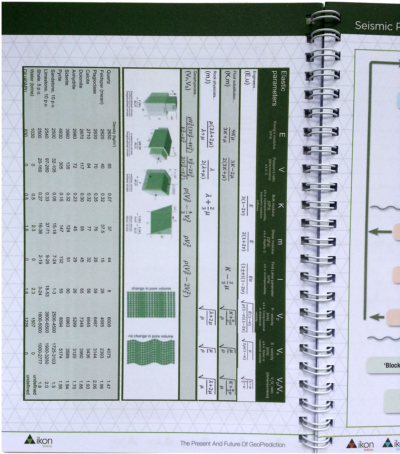
Agile's rock physics cheatsheet. Sort of.At EAGE I picked up Ikon Science's latest swag, a coil-bound notebook. On page 8, I found a modified version of our rock physics cheatsheet. "Hey, that's neat, someone thinks it's useful!" But then I thought, "Darn, I wish they'd mentioned us." Like nearly all of the work we do that's online, it's labelled CC-BY. Meaning anyone can use it, however they want, but with attribution

It's incredibly rewarding to see our stuff being used and spreading. That's why we put it out there. And by using a CC-BY license, we hope others will distribute, remix, tweak, and build upon our work, even commercially, as long as they credit us for the original creation. Creators have a choice when they are sharing, and because we want the maximum dissemination possible, we often choose the most accommodating license.

Why don't we completely relinquish our rights and opt out of copyright altogether? Because we want recognition for our work, and the attribution brings us connection

The best people I have met are the ones who are generous, connected, and open. Being diligent with attribution isn't easy, but it plays an important part in being awesome.

A stupid seismic model from core

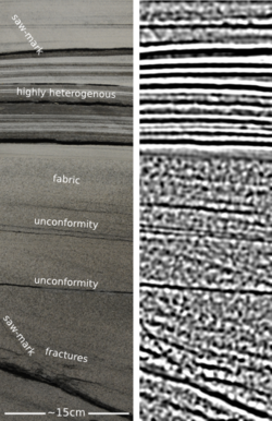
On the plane back from Calgary, I got an itch to do some image processing on some photographs I took of the wonderful rocks on display at the core convention. Almost inadvertently, I composed a sequence of image filters that imitates a seismic response. And I came to these questions:  

  • Is this a viable way to do forward modeling? 
  • Can we exploit scale invariance to make more accurate forward models?
  • Can we take the fabric from core and put it in a reservoir model?
  • What is the goodness of fit between colour and impedance? 

Click to enlargeAbove all, this image processing excerise shows an unambiguous demonstration of the effects of bandwidth. The most important point, no noise has been added. Here is the sequence, it is three steps: convert to grayscale, compute Laplacian, apply bandpass filter. This is analgous to the convolution of a seismic wavelet and the earth's reflectivity. Strictly speaking, it would be more physically sound to make a forward model using wavelet convolution (simple) or finite difference simulation (less simple), but that level of rigour was beyond the scope of my tinkering.

The two panels help illustrate a few points. First, finely layered heterogeneous stratal packages coalesce into crude seismic events. This is the effect of reducing bandwidth. Second, we can probably argue about what is 'signal' and what is 'noise'. However, there is no noise, per se, just geology that looks noisy. What may be mistaken as noise, might in fact be bonafide interfaces within material properties. 

If the geometry of geology is largely scale invariant, perhaps, just perhaps, images like these can be used at the basin and reservoir scale. I really like the look of the crumbly fractures near the bottom of the image. This type of feature could drive the placement of a borehole, and the production in a well. The patches, speckles, and bands in the image are genuine features of the geology, not issues of quality or noise. 

Do you think there is a role for transforming photographs of rocks into seismic objects?

The developer's mind

Humbled by the aura of the legendary Cavendish Labs sitting in the adjacent building next door, I refrain from expressing the full extent of my awe and reverence for this special place. "Sure", I think, "it's no big deal. Let's get on with it". I came to Cambridge to collaborate with Pietro Berkes. He's building Canopy Geo at Enthought. We spent the day spiking, apparently. Working shoulder to shoulder with Pietro was nearly as responsive as dictating a vision to a painter and watching it emerge before my eyes. He's darn good. During my visit, I took notice of some characteristics and guiding principles that top developers, such as himself and his colleagues, bring to their work.

On whiteboarding

The best way to be understood, to connect, or to teach, is to do it one-on-one in front of a whiteboard. It is fitting that all of the walls of their office space are whiteboard walls. Old marks wiped clean but still visible show remnant algorithms sketched out and stacked up upon each other. A well-worn workshop, where writing on the walls is the cultural norm. And for electronic communication? Some are deliberate to only check emails three times a day: first thing in the morning, midday, and mid afternoon. Any more often, would be disruptive to their flow. Email is the enemy of real work, but instant messaging can be be a good productivity tool. 

On discipline

To build something that is extensible takes a good deal of thoughfulness and discipline. Code will survive long after the project is over and the programmer has moved on. This doesn't just mean leaving an adequate documentation trail behind you, but also building a solid foundation that others can contribute to. Being Agile, it turns out, although not the only choice, also takes discipline and diligence in order to be effective. 

On ownership and responsibilty 

Authority is not given, responsibility is taken. Many of the best developers define themselves by the authorship of code and libraries. So attribution is not only necessary politeness, it is a direct line of communication. What body of work would you stand up and speak for? Someone may find a bug at 9:00 am in a different time zone. Will they wait till 2:00 pm to hear from you? Somehow, this decentralized system of self-appointed responsibilty just works. The longevity of emotional and intellectual labour, particuarly in an open source setting, is a fascinating concept. The work becomes more relevant because the developer never stops caring for it. You can change projects, you can change languages, you can change companies, but your work never leaves you. If that notion excites you, you are making an impact. 

The developer knows that prowess is earned by execution. They thrive in an accepted sub-culture of meritocracy: largely free of politics, organizational hierarchies, and other social drama that get in the way of the real work. With a mind cleared to deal with essential tasks, what emerges is the ego of an artist and a creator with the potential to act on it. "Now that we can build anything, what do we do next?"  

Capturing conferences

Yesterday I grumbled about secret meetings. Enough whining, what's the opportunity?

Some technical societies already understand the need for recording proceedings. SPE workshops have clearly-stated deliverables, for example at the Marginal Fields workshop in Cairo later this year:

SPE workshop deliverables

That's more like it. It would be better to publish the proceedings to the world, not just attendees, and to use an open license, but it's definitely a good start.

As we reported earlier, we used a variety of methods to capture the unsession we hosted at the Canada GeoConvention in May — video, photos, drawings and notes, interviews, a wiki, and an article. This is messy and chaotic, but it's also transparent and open, making it easier to reference and more likely that someone (including us!) can use it.

What other things should we be considering? Here are some ideas:

  • Livestreaming. This enables people who couldn't make it to take part in at least one or two sessions via streaming video and social media. It's amazingly effective and can increase the audience by a factor of 5 or more. Even better: at the end of it, you have video of everything!
  • Published proceedings. This is something we used to do all the time in geoscience, but it takes a lot of coordination. The GSL is the only body I know of that still manages it regularly. Perhaps a wiki-based publishing approach would be easier to arrange?
  • Graphic recording. I have witnessed this a few times, and even tried it myself. In a workshop, it's a terrific way to engage the audience in real time; in a conference, it makes for some great conversation pieces in the break. It's also a brilliant way to listen.
  • Podcasting. Having a small team of reporters capture the proceedings in short interviews, video clips, and opinion pieces could be a fun way to engage non-attendees, and leave the event with a record of what went on.
  • Code and data. We could experiment with more 'doing' sessions, where code is written, wiki pages are hacked on, data is collected, and so on. The product then is clear: a new code repository, open dataset, or set of wiki pages. This one could be the easiest one to pull off, and the most valuable to the community.

Here's more inspiration: the EGU tweeting its round-up from Vienna this morning:

Looking back at the #EGU2013 - a whole lot of online action, excellent scientists, geo-photos, journals & more ow.ly/lE0jH#GeoQ — EGU (@EuroGeosciences) June 6, 2013

Have you seen unusually effective or innovative ways to record events you've been at? What would you like to see? What would you be prepared to do?


Update on 2013-06-07 21:51 by Matt Hall

In my inbox today: SEG are offering video of something like 200 talks (of the 1000+) from last year's Annual Meeting. Unfortunately, they're trying to monetize, but at least they're only $0.99. I enjoyed this one on 3D image segmentation live — but haven't tried it online.

The forum that never happened

Recently, I keep seeing this on SEG meeting information:

Note: The mechanical recording of any portion of the [meeting] in any form (photographic, electronic, etc.) is strictly prohibited. Printed reference to the [...] presentations or discussions is not permitted without the consent of the parties involved. All participants are requested to omit public reference to the [...] proceedings in any published work or oral presentation. Only registrants are permitted to attend Forum sessions. Each participant agrees to these regulations when application is accepted [...]

Interesting! 'Regulations' about what a person can and can't say or write about a scientific meeting, a sort of gag order. It goes further: in an attempt to limit what is revealed to the outside world, abstracts are not required at some meetings, only short descriptions. There shall be no evidence of the talk even taking place.

I am convinced that meetings like this are unhelpful, unscientific, and unproductive. Here's why:

We are free. I am a professional scientist and I own my brain. If I want to talk about my field with other professionals, in public if I so wish, then I am entitled to do that. Of course I won't disclose proprietary information, but that's different — proprietary information hasn't been presented at a conference of my competitors.

Public is public. Here's how a forum should work: people should present things they wish to make public. When they're public, they're public, end of story. Asking for secret meetings is like asking for privacy on Facebook. If you want secret, pick up the phone or huddle in dark corners. Or consider the Chatham House Rule.

Ilya Repin, The Secret Meeting

Secrecy is a bug, not a feature. SEG is a technical society for the advancement of applied geophysics and those who practise it. It's not The Magic Circle. The difference between science and magic is that in science, we do things transparently whenever we can. I know industry is a bit different, but in the interests of innovation and excellence, we need more openness, not less.

No product? No point. If you organize a workshop and there is no tangible outcome — no abstracts, no proceedings (remember those?), no recording — then it's my conviction that there was no point in your workshop, except perhaps for the handful of people who came.

Down with elitism. Surely SEG stands for technical excellence among all of its members, not just the privileged few with the time and resources to write papers and travel to workshops? If you're using the resources of technical societies (their time, attention, and marketing clout) then I believe it's your duty to the membership, and to the science as a whole, to share.

An unsolved problem. Corporate secrecy was identified as one of the top unsolved problems of subsurface science in our recent unsession. So what are we playing at? Are we professionals and scientists or just industrial magicians, selfishly hoarding our ideas and data, and slowing innovation down for everyone? What do you think?

Proceedings of an unsession

Two weeks ago today Evan and I hosted a different kind of session at the Canada GeoConvention. It was an experiment in collaboration and integration, and I'm happy to say it exceeded our expectations. We will definitely be doing it again, so if you were there, or even if you weren't, any and all feedback will help ensure the dial goes to 11.

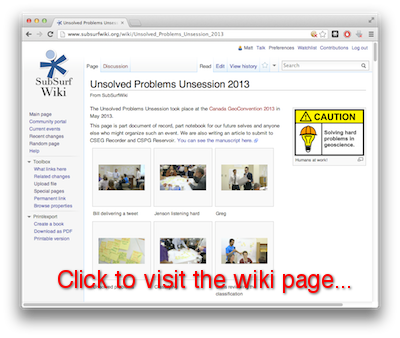
One of the things we wanted from the session was evidence. Evidence of conversation, innovation, and creative thinking. We took home a great roll of paper and sticky notes, and have now captured it all in SubSurfWiki, along with notes from the event. You are invited to read and edit. Be bold! And please share the link...

  ageo.co/unsession

The video from the morning is in the editing suite right now: watch for that too.

Post-It NoteWe have started a write-up of the morning. If you came to the session, please consider yourself a co-author: your input and comments are welcome. You might be unaccustomed to editing a community document, but don't be shy — that's what it's there for. 

We want to share two aspects of the event on the blog. First, the planning and logistics of the session — a cheatsheet for when we (or you!) would like to repeat the experience. Second, the outcomes and insights from it — the actual content. Next time: planning an unsession.

Fitting a model to data

In studying the earth, we can't afford to take enough observations, and they will never be free of noise. So if you say you do geoscience, I hereby challenge you to formulate your work as a mathematical inverse problem. Inversion is a question: given the data, the physical equations, and details of the experiment, what is the distribution of physical properties? To answer this question we must address three more fundamental ones (Scales, Smith, and Treitel, 2001):

  • How accurate is the data? Or what does fit mean?
  • How accurately can we model the response of the system? Have we included all the physics that can contribute signifcantly to the data?
  • What is known about the system independent of the data? There must be a systematic procedure for rejecting unreasonable models that fit the data as well.

Setting up an inverse problem means coming up with the equations that contain the physics and geometry of the system under study. The method for solving it depends on the nature of the system of equations. The simplest is the minimum norm solution, and you've heard of it before, but perhaps under a different name.

To fit is to optimize a system of equations

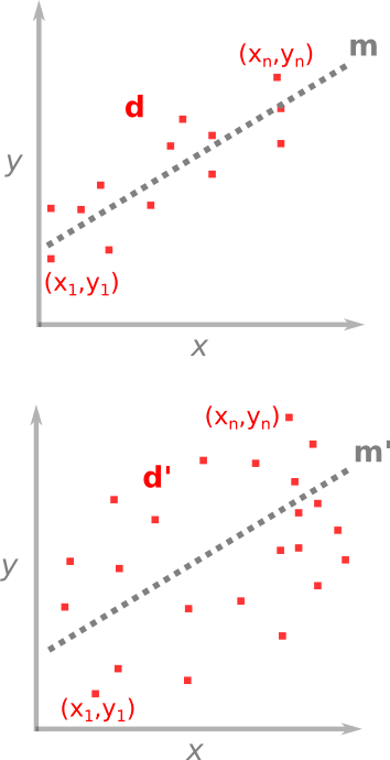
For problems where the number of observations is greater than the number of unknowns, we want to find which unknowns fit the best. One case you're already familiar with is the method of least squares — you've used it fitting a line of through a set of points. A line is unambiguously described by only two parameters: slope a and y-axis intercept b. These are the unknowns in the problem, they are the model m that we wish to solve for. The problem of line-fitting through a set of points can be written out like this,

As I described in a previous post, the system of the problem takes the form d = Gm, where each row links a data point to an equation of a line. The model vector m (M × 1), is smaller than the data d (N × 1) which makes it an over-determined problem, and G is a N × M matrix holding the equations of the system.

Why cast a system of equations in this matrix form? Well, it turns out that the the best-fit line is precisely,

which are trivial matrix operations, once you've written out G.  T means to take the transpose, and –1 means the inverse, the rest is matrix multiplication. Another name for this is the minimum norm solution, because it defines the model parameters (slope and intercept) for which the lengths (vector norm) between the data and the model are a minimum. 

One benefit that comes from estimating a best-fit model is that you get the goodness-of-fit for free. Which is convenient because making sense of the earth doesn't just mean coming up with models, but also expressing their uncertainty, in terms of the errors with which they are linked.

I submit to you that every problem in geology can be formulated as a mathematical inverse problem. The benefit of doing so is not just to do math for math's sake, but it is only through quantitatively portraying ambiguous inferences and parameterizing non-uniqueness that we can do better than interpreting or guessing. 

Reference (well worth reading!)

Scales, JA, Smith, ML, and Treitel, S (2001). Introductory Geophysical Inverse Theory. Golden, Colorado: Samizdat Press

Laying it all out at the Core Conference

Bobbing in the wake of the talks, the Core Conference turned out to be more exemplary of this year's theme, Integration. Best of all were SAGD case studies, where multi-disciplinary experiments are the only way to make sense of the sticky stuff.

Coring through steam

Travis Shackleton from Cenovus did a wonderful presentation showing the impact of bioturbation, facies boundaries, and sedimentary structures on steam chamber evolution in the McMurray Formation at the FCCL project. And because I had the chance to work on this project with ConocoPhillips a few years ago, but didn't, this work induced both jealousy and awe. Their experiment design is best framed as a series of questions:

  • What if we drilled, logged, and instrumented two wells only 10 m apart? (Awesome.)
  • What if we collected core in both of them? (Double awesome.)
  • What if the wells were in the middle of a mature steam chamber? (Triple awesome.)
  • What if we collected 3D seismic after injecting all this steam and compare with with a 3D from before? (Quadruple awesome.)

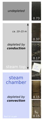
It is the first public display of SAGD-depleted oil sand, made available by an innovation of high-temperature core recovery. Travis pointed to a portion of core that had been rinsed by more than 5 years of steam circulating through it. It had a pale brown color and a residual oil saturation SO of 15% (bottom sample in the figure). Then he pointed to a segment of core above the top of the steam chamber. It too was depleted, by essentially the same amount. You'd never know just by looking. It was sticky and black and largely unscathed. My eyes were fooled, direct observation deceived.

A bitumen core full of fractures

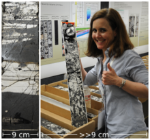
Jen-Russel-Houston held up a half-tube of core of high-density fractures riddled throughout bitumen saturated rock. The behemoth oil sands that require thermal recovery assistance have an equally promising but lesser known carbonate cousin, still in its infancy. It is the bitumen saturated Grosmont Formation, located to the west of the more mature in-situ projects in sand. The reservoir is entirely dolomite, hosting its own unique structures affecting the spreading of steam and the reduction of bitumen's viscosity to a flowable level.

Jen and her team at OSUM hope their pilot will demonstrate that these fractures serve as transport channels for the steam, allowing it to creep around tight spots in the reservoir, which would otherwise be block the steam in its tracks. These are not the same troubling baffles and barriers caused by mud plugs or IHS, but permeability heterogeneities caused by the dolomitization process. A big question is the effective permeability at the length scales of production, which is phenomenologically different to measurements made from cut core. I overheard a spectator suggest to Jen that she try to freeze a sleeve of core, soak it with acid then rinse the dolomite out the bottom. After which only a frozen sculpture of the bitumen would remain. Crazy? Maybe. Intriguing? Indeed. 

Let's do more science with rocks!

Two impressive experiments, unabashedly and literally laid out for all to see, equipped with clever geologists, and enriched by supplementary technology. Both are thoughtful initiatives—real scientific experiments—that not only make the operating companies more profitable, but also profoundly improve our understanding of a precious resource for society. Two role models for how comprehensive experiments can serve more than just those who conduct them. Integration at its very best, centered on core.

What are the best examples of integrated geoscience that you've seen?

Submitting assumptions for meaningful answers

The best talk of the conference was Ran Bachrach's on seismics for unconventionals. He enthusiastically described the physics to his spectators with conviction and duty, and explained why they should care. Isotropic, VTI, and orthorhombic media anisotropy models are used not because they are right, but because they are simple. If the assumptions you bring to the problem are reasonable, the answers can be considered meaningful. If you haven't considered and tested your assumptions, you haven't subscribed to reason. In a sense, you haven't held up your end of the bargain, and there will never be agreement. This talk should be mandatory viewing for anyone working seismic for unconventionals. Advocacy for reason. Too bad it wasn't recorded.

I am both privileged and obliged to celebrate such nuggets of awesomeness. That's a big reason why I blog. And on the contrary, we should call out crappy talks when we see them to raise the bar. Indeed, to quote Zen Faulkes, "...we should start creating more of an expectation that scientific talks will be reviewed and critiqued. And names will be named."

The talk from HEF Petrophysical entitled, Towards modelling three-dimensional oil sands permeability distribution using borehole image logs, drew me in. I was curious enough to show up. But as the talk unfolded, my curiosity was left unsatisfied. A potentially interesting workflow of transforming high-resolution resistivity measurements into flow permeability was obfuscated with a pointless upscaling step. The meat of anything like this is in the transform itself, but it was missing. It's also the most trivial bit; just cross-plot one property with another and show people. So I am guessing they didn't have any permeability data. If that was the case, how can you stand up and talk about permeability? It was a sandwich without the filling. The essential thing that defines a piece of work is the creativity. The thing you add that wasn't there before. I was disappointed. Disappointed that it was accepted, and that no one else piped up. 

I will paraphrase a conversation I had with Ran at the coffee break: Some are not aware, some choose to ignore, and some forget that works of geoscience are problems of extreme complexity. In fact, the only way we can cope with complexity is to make certain assumptions that make our problem solvable. If all you do is say "here is my solution", you suck. But if instead you ask, "Have I convinced you that my assumptions are reasonable?", it entirely changes the conversation. It entirely changes the specialist's role. Only when you understand your assumptions can we talk about whether the results are reasonable. 

Have you ever felt conflicted on whether or not you should say something?